IMAGES TAKEN NEAR TO
Marygate Lane, YORK, YO30 7BJ
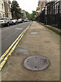
Introduction
This page details the photographs taken nearby to Marygate Lane, YO30 7BJ by members of the Geograph project.
The Geograph project started in 2005 with the aim of publishing, organising and preserving representative images for every square kilometre of Great Britain, Ireland and the Isle of Man.

There are currently over 7.5m images from over14,400 individuals and you can help contribute to the project by visiting https://www.geograph.org.uk
Image Map (Loading...)


Getting Data...Please wait
Leaflet Map data © OpenStreetMap
Images are licensed for reuse under creativecommons.org/licenses/by-sa/2.0
Notes
- Clicking on the map will re-center to the selected point.
- The higher the marker number, the further away the image location is from the centre of the postcode.
Image Listing (1248 Images Found)
Images are licensed for reuse under creativecommons.org/licenses/by-sa/2.0
Image
Details
Distance
1
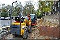
Constructing a new ramp
A new ramp linking Marygate to St. Mary's Lane.
Image: © DS Pugh
Taken: 12 Nov 2023
0.01 miles
2
Cobbled street beside Marygate car park
The lane leads to the railway bridge under the Scarborough lines.
Image: © DS Pugh
Taken: 19 Mar 2023
0.02 miles
3
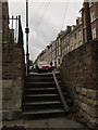
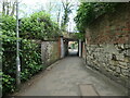
Steps, St Mary's, York
The steps lead down from the end of the road to an underpass under the railway Image A cycle wheel channel has been provided.
Image: © Stephen Craven
Taken: 31 Aug 2015
0.02 miles
4
Posts and bollard, Marygate Lane, York
On the route of York's longest snicket, as mapped in 'A Walk around the Snickelways of York', by Mark W. Jones [2nd edition, 1984]. A snickelway is a narrow passageway or alley between walls, fences or buildings.
Image: © Christine Johnstone
Taken: 16 May 2023
0.02 miles
5
Coal-holes, St Mary's, York
This terrace of 1860s houses is listed grade 2 (list entry number 1256774) and the listing describes it as "a very well preserved example of a Victorian terrace." Among the details is the individual coal cellar for each house, under the pavement.
Image: © Stephen Craven
Taken: 31 Aug 2015
0.03 miles
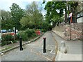
6
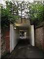
Railway underpass, Marygate Lane, York
The underpass continues along the line of Marygate Lane, which continues beyond here as an urban footpath to Queen Anne's Road. The railway is the York to Scarborough line.
Image: © Stephen Craven
Taken: 31 Aug 2015
0.04 miles
7
Railway underbridge, Bootham, York
On the route of York's longest snicket, as mapped in 'A Walk around the Snickelways of York', by Mark W. Jones [2nd edition, 1984]. A snickelway is a narrow passageway or alley between walls, fences or buildings.
Image: © Christine Johnstone
Taken: 16 May 2023
0.04 miles
8
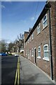
Houses on Marygate Lane
The houses overlook Marygate car park.
Image: © DS Pugh
Taken: 19 Mar 2023
0.04 miles
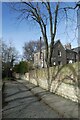
9
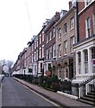
St Mary's
St Mary's is a street leading off Bootham and was developed around 1840-50.
Image: © Gordon Hatton
Taken: 2 Mar 2012
0.04 miles
10
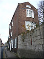
29 Marygate, York
A late 18th century house abutting the wall surrounding the precinct of St Mary's Abbey. The house is now used as offices by an architectural practice.
Image: © Phil Champion
Taken: 21 Nov 2010
0.05 miles