IMAGES TAKEN NEAR TO
Rawcliffe Grove, YORK, YO30 6NR
Introduction
This page details the photographs taken nearby to Rawcliffe Grove, YO30 6NR by members of the Geograph project.
The Geograph project started in 2005 with the aim of publishing, organising and preserving representative images for every square kilometre of Great Britain, Ireland and the Isle of Man.

There are currently over 7.5m images from over14,400 individuals and you can help contribute to the project by visiting https://www.geograph.org.uk
Image Map
Images are licensed for reuse under creativecommons.org/licenses/by-sa/2.0
Notes
- Clicking on the map will re-center to the selected point.
- The higher the marker number, the further away the image location is from the centre of the postcode.
Image Listing (12 Images Found)
Images are licensed for reuse under creativecommons.org/licenses/by-sa/2.0
Image
Details
Distance

4

Tinned-up empty housing, Barleyfields, Clifron
On the route of York's longest snicket, as mapped in 'A Walk around the Snickelways of York', by Mark W. Jones [2nd edition, 1984]. A snickelway is a narrow passageway or alley between walls, fences or buildings.
Image: © Christine Johnstone
Taken: 16 May 2023
0.22 miles
6
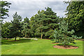
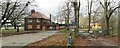
Homestead Park
14 acre park opened in 1904 by Benjamin Seebohm Rowntree, son of Joseph Rowntree, and owned and maintained by the Joseph Rowntree Foundation. Adjacent Homestead House, home of Benjamin from 1904 to 1936, is now the headquarters of the foundation.
Image: © Ian Capper
Taken: 20 Jul 2017
0.22 miles
7
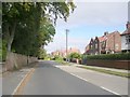
Water Lane - viewed from Brompton Road
Image: © Betty Longbottom
Taken: 25 Sep 2010
0.22 miles
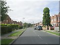
9
Water Lane - viewed from Brompton Road
Image: © Betty Longbottom
Taken: 25 Sep 2010
0.23 miles
10

Flytipped rubbish, Barleyfields, Clifton
On the route of York's longest snicket, as mapped in 'A Walk around the Snickelways of York', by Mark W. Jones [2nd edition, 1984]. A snickelway is a narrow passageway or alley between walls, fences or buildings.
Image: © Christine Johnstone
Taken: 16 May 2023
0.24 miles