IMAGES TAKEN NEAR TO
Westminster Road, YORK, YO30 6LZ
Introduction
This page details the photographs taken nearby to Westminster Road, YO30 6LZ by members of the Geograph project.
The Geograph project started in 2005 with the aim of publishing, organising and preserving representative images for every square kilometre of Great Britain, Ireland and the Isle of Man.

There are currently over 7.5m images from over14,400 individuals and you can help contribute to the project by visiting https://www.geograph.org.uk
Image Map (Loading...)


Getting Data...Please wait
Leaflet Map data © OpenStreetMap
Images are licensed for reuse under creativecommons.org/licenses/by-sa/2.0
Notes
- Clicking on the map will re-center to the selected point.
- The higher the marker number, the further away the image location is from the centre of the postcode.
Image Listing (182 Images Found)
Images are licensed for reuse under creativecommons.org/licenses/by-sa/2.0
Image
Details
Distance
1
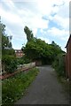
Path near Compton Street
Looking along a path from Clifton Green to St. Peter's School.
Image: © DS Pugh
Taken: 14 Jun 2022
0.05 miles
3
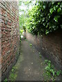
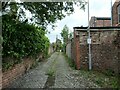
Path near Clifton Dale
On the route of York's longest snicket, as mapped in 'A Walk around the Snickelways of York', by Mark W. Jones [2nd edition, 1984]. A snickelway is a narrow passageway or alley between walls, fences or buildings.
Image: © Christine Johnstone
Taken: 16 May 2023
0.06 miles
4
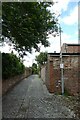
Back Compton Street
Looking along the back alley behind houses on Compton Street and Clifton Dale.
Image: © DS Pugh
Taken: 14 Jun 2022
0.06 miles
5
Back lane between Clifton Dale and Compton Street
In the York suburb of Clifton.
Image: © Christine Johnstone
Taken: 16 May 2023
0.06 miles
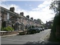
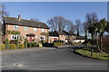
6
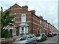
Houses on the west side of Compton Street
Built between 1889 and 1907 in the York suburb of Clifton.
Image: © Christine Johnstone
Taken: 16 May 2023
0.06 miles
7
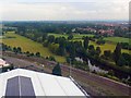
A view from The Yorkshire Wheel, National Rail Museum, York
This view is slightly to the west of north. The roof in the foreground is that of the National Rail Museum with the railway as it leaves York station out of shot behind the viewpoint. The river is the Ouse. Apologies for the cast in this series of images: they were taken through perspex on a rather murky day.
Image: © Brian Robert Marshall
Taken: 16 Jun 2008
0.07 miles
9
Clifton Green
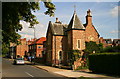
This house faces Clifton Green close to Water End and has a stone inscribed with "St. OL's PH. 1846".
Image: © David Rogers
Taken: 30 Jun 2008
0.08 miles
10
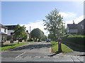
Government House road looking South East
Image: © Michael Jagger
Taken: 7 Mar 2010
0.09 miles