IMAGES TAKEN NEAR TO
John Burrill Homes, Water End, YORK, YO30 6LR
Introduction
This page details the photographs taken nearby to John Burrill Homes, Water End, YO30 6LR by members of the Geograph project.
The Geograph project started in 2005 with the aim of publishing, organising and preserving representative images for every square kilometre of Great Britain, Ireland and the Isle of Man.

There are currently over 7.5m images from over14,400 individuals and you can help contribute to the project by visiting https://www.geograph.org.uk
Image Map (Loading...)


Getting Data...Please wait
Leaflet Map data © OpenStreetMap
Images are licensed for reuse under creativecommons.org/licenses/by-sa/2.0
Notes
- Clicking on the map will re-center to the selected point.
- The higher the marker number, the further away the image location is from the centre of the postcode.
Image Listing (140 Images Found)
Images are licensed for reuse under creativecommons.org/licenses/by-sa/2.0
Image
Details
Distance
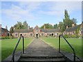
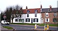
1
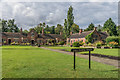
John Burrill Homes
Almshouses on for 7 people and a caretaker built on Water End in three single storey blocks completed in 1931 and funded by a bequest from John Burrill "for aged persons over 60". John Burrill was a local resident and director of York grocers Border and Co, who had bought this land in 1918.
The three buildings are separately grade II listed: for the two here see www.historicengland.org.uk/listing/the-list/list-entry/1256265 and www.historicengland.org.uk/listing/the-list/list-entry/1256266 and for the third, situated off the left hand side of the photo and a mirror of the one on the right, see www.historicengland.org.uk/listing/the-list/list-entry/1256264.
Image: © Ian Capper
Taken: 20 Jul 2017
0.01 miles
2
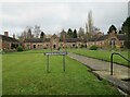
John Burrill Homes
These almshouses were built in 1925-31 by the architects Ward and Leckenby. They were seven one-story brick homes, each with several rooms. In his will of 1924 John Burrill stated simply that the homes should be made for aged persons over 60.
https://historicengland.org.uk/services-skills/education/educational-images/john-burrill-homes-water-end-7933
Image: © Les Hull
Taken: 20 Feb 2023
0.01 miles
3
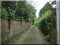
Access lane, John Burrill Homes, Clifton
On the route of York's longest snicket, as mapped in 'A Walk around the Snickelways of York', by Mark W. Jones [2nd edition, 1984]. A snickelway is a narrow passageway or alley between walls, fences or buildings.
Image: © Christine Johnstone
Taken: 16 May 2023
0.02 miles
4
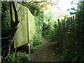
Path between Water End and Barleyfields
On the route of York's longest snicket, as mapped in 'A Walk around the Snickelways of York', by Mark W. Jones [2nd edition, 1984]. A snickelway is a narrow passageway or alley between walls, fences or buildings.
Image: © Christine Johnstone
Taken: 16 May 2023
0.02 miles
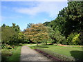
7
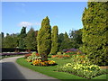
Homestead Park Flowerbeds - Water End
Image: © Betty Longbottom
Taken: 25 Sep 2010
0.03 miles
8
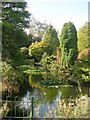
Homestead Park Lily Pond - Water End
Image: © Betty Longbottom
Taken: 25 Sep 2010
0.04 miles
9
Cottages on Clifton Green
The most attractive side of Clifton Green is the north side, where there are several early 19th century cottages, often part hidden behind lines of traffic queueing for the traffic lights.
Image: © Gordon Hatton
Taken: 2 Mar 2012
0.04 miles
10

Water End, York
The road leads up to Clifton Bridge over the River Ouse, seen from the north western corner of Clifton Green
Image: © Paul Harrop
Taken: 9 Aug 2016
0.05 miles