IMAGES TAKEN NEAR TO
Peter Hill Drive, YORK, YO30 6JS
Introduction
This page details the photographs taken nearby to Peter Hill Drive, YO30 6JS by members of the Geograph project.
The Geograph project started in 2005 with the aim of publishing, organising and preserving representative images for every square kilometre of Great Britain, Ireland and the Isle of Man.

There are currently over 7.5m images from over14,400 individuals and you can help contribute to the project by visiting https://www.geograph.org.uk
Image Map (Loading...)


Getting Data...Please wait
Leaflet Map data © OpenStreetMap
Images are licensed for reuse under creativecommons.org/licenses/by-sa/2.0
Notes
- Clicking on the map will re-center to the selected point.
- The higher the marker number, the further away the image location is from the centre of the postcode.
Image Listing (16 Images Found)
Images are licensed for reuse under creativecommons.org/licenses/by-sa/2.0
Image
Details
Distance
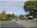
1
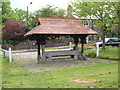
Horse Trough
Clifton Green, York. On the A19
Image: © Alison Stamp
Taken: 21 May 2005
0.04 miles
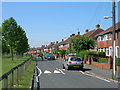
2
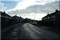
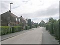
Spalding Avenue
Looking along Spalding Avenue near Burdyke Avenue on a cold day.
Image: © DS Pugh
Taken: 7 Jan 2021
0.12 miles
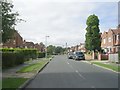
3
Water Lane - viewed from Brompton Road
Image: © Betty Longbottom
Taken: 25 Sep 2010
0.15 miles
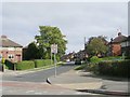
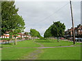
7
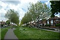
Path on Kingsway North
Looking along a path in the middle of the wide street.
Image: © DS Pugh
Taken: 29 May 2021
0.19 miles