IMAGES TAKEN NEAR TO
Burton Green, YORK, YO30 6JE
Introduction
This page details the photographs taken nearby to Burton Green, YO30 6JE by members of the Geograph project.
The Geograph project started in 2005 with the aim of publishing, organising and preserving representative images for every square kilometre of Great Britain, Ireland and the Isle of Man.

There are currently over 7.5m images from over14,400 individuals and you can help contribute to the project by visiting https://www.geograph.org.uk
Image Map (Loading...)


Getting Data...Please wait
Leaflet Map data © OpenStreetMap
Images are licensed for reuse under creativecommons.org/licenses/by-sa/2.0
Notes
- Clicking on the map will re-center to the selected point.
- The higher the marker number, the further away the image location is from the centre of the postcode.
Image Listing (20 Images Found)
Images are licensed for reuse under creativecommons.org/licenses/by-sa/2.0
Image
Details
Distance
1
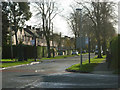
Burton Stone Lane, Clifton
This is the northern end of Burton Stone Lane, a leafy residential avenue that stretches to Clifton. It takes its name from the Burton Stone which was the base of a City of York boundary cross.
Image: © Stephen McKay
Taken: 3 Nov 2009
0.07 miles
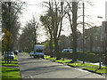
2
Kingsway North, Clifton
This is the northern end of Kingsway North on the edge of the estate, where traffic must turn right into Burton Stone Lane or left into a primary school.
Image: © Stephen McKay
Taken: 3 Nov 2009
0.08 miles
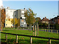
3

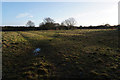
Flats and houses at Burton Green
From railway crossing looking across Recreation Grounds
Image: © John Firth
Taken: 10 May 2014
0.10 miles
5
Burton Stone Lane, Clifton
A leafy suburban avenue seen from the junction with Rowntree Avenue.
Image: © Stephen McKay
Taken: 3 Nov 2009
0.13 miles
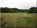
6
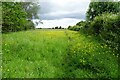
Path through the buttercups near Wigginton Road
Accessing this path from Wigginton Road involves passing through tall nettles and an overgrown hawthorn hedge to reach the gate. The York to Scarborough railway line is on the right.
Image: © DS Pugh
Taken: 8 Jun 2024
0.18 miles
8
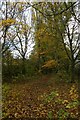
Path beside the railway
Looking through woodland with autumnal leaves falling.
Image: © DS Pugh
Taken: 25 Oct 2020
0.18 miles
9
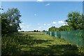
Fence beside the railway
Looking along a footpath beside the York to Scarborough lines.
Image: © DS Pugh
Taken: 8 Jul 2021
0.20 miles
10
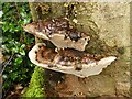
New Earswick Nature Reserve ? Bracket fungus on a stump
The reserve was formed on the site of the brickworks created to provide bricks for the early stages of development of New Earswick village from around 1900. It closed in 1933 and the area became wild.
In 1973 it was established as a Designated Educational Nature Reserve, since 2019 leased to the group formed some years previously to manage the reserve. The pool resulted from the extraction of clay for the bricks and is naturally filled from groundwater. The only other physical remains are a section of brick paving, possibly the base of a beehive kiln, and the concrete base of the windpump used to keep the claypit free of water. Due to vandalism, the reserve has had to be securely enclosed and is only open to keyholders and on limited open days.
Image: © Alan Murray-Rust
Taken: 4 Dec 2022
0.20 miles