IMAGES TAKEN NEAR TO
The Avenue, YORK, YO30 6AU
Introduction
This page details the photographs taken nearby to The Avenue, YO30 6AU by members of the Geograph project.
The Geograph project started in 2005 with the aim of publishing, organising and preserving representative images for every square kilometre of Great Britain, Ireland and the Isle of Man.

There are currently over 7.5m images from over14,400 individuals and you can help contribute to the project by visiting https://www.geograph.org.uk
Image Map
Images are licensed for reuse under creativecommons.org/licenses/by-sa/2.0
Notes
- Clicking on the map will re-center to the selected point.
- The higher the marker number, the further away the image location is from the centre of the postcode.
Image Listing (167 Images Found)
Images are licensed for reuse under creativecommons.org/licenses/by-sa/2.0
Image
Details
Distance
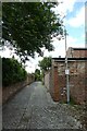
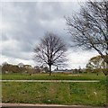
2
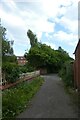
Path near Compton Street
Looking along a path from Clifton Green to St. Peter's School.
Image: © DS Pugh
Taken: 14 Jun 2022
0.06 miles
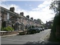
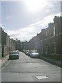
3
Houses on the west side of Compton Street
Built between 1889 and 1907 in the York suburb of Clifton.
Image: © Christine Johnstone
Taken: 16 May 2023
0.07 miles
4
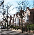
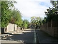
The Avenue, Clifton
Middle class development of the late 19th century for those wishing to move out of the city to the 'village' atmosphere of Clifton.
Image: © Gordon Hatton
Taken: 30 Jan 2008
0.08 miles
5
Back Compton Street
Looking along the back alley behind houses on Compton Street and Clifton Dale.
Image: © DS Pugh
Taken: 14 Jun 2022
0.08 miles
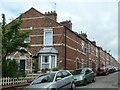
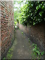
6
Back lane between Clifton Dale and Compton Street
In the York suburb of Clifton.
Image: © Christine Johnstone
Taken: 16 May 2023
0.08 miles
8
St Peter's School and church
Viewed from the river. The school has strong associations with Guy Fawkes https://www.stpetersyork.org.uk/archives/guy_fawkes
Image: © Gerald England
Taken: 14 Apr 2019
0.09 miles
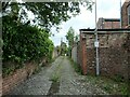
9
Path near Clifton Dale
On the route of York's longest snicket, as mapped in 'A Walk around the Snickelways of York', by Mark W. Jones [2nd edition, 1984]. A snickelway is a narrow passageway or alley between walls, fences or buildings.
Image: © Christine Johnstone
Taken: 16 May 2023
0.09 miles