IMAGES TAKEN NEAR TO
Shipton Road, YORK, YO30 5YA
Introduction
This page details the photographs taken nearby to Shipton Road, YO30 5YA by members of the Geograph project.
The Geograph project started in 2005 with the aim of publishing, organising and preserving representative images for every square kilometre of Great Britain, Ireland and the Isle of Man.

There are currently over 7.5m images from over14,400 individuals and you can help contribute to the project by visiting https://www.geograph.org.uk
Image Map (Loading...)


Getting Data...Please wait
Leaflet Map data © OpenStreetMap
Images are licensed for reuse under creativecommons.org/licenses/by-sa/2.0
Notes
- Clicking on the map will re-center to the selected point.
- The higher the marker number, the further away the image location is from the centre of the postcode.
Image Listing (81 Images Found)
Images are licensed for reuse under creativecommons.org/licenses/by-sa/2.0
Image
Details
Distance
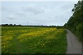
1
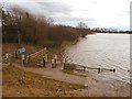
White Rose Cycle Route
The National Route 65 of the National Cycle Network is known as the White Rose Cycle Route and runs between Middlesbrough and Hull. This riverside section into York is going to be a struggle when the Ouse has raised levels of water and the sluice gates have been opened to flood the Rawcliffe Ings.
Image: © Andy Farrington
Taken: 6 Feb 2011
0.03 miles
2
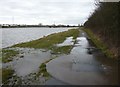
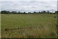
Rawcliffe Ings
Only a couple of yards of this cycle route and footpath were passable when I took this picture. The Ings left had been flooded to protect York from further flood damage. Left of picture on the horizon is the A1237 and the bridge over the River Ouse.
Image: © Andy Farrington
Taken: 6 Feb 2011
0.03 miles
3
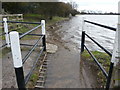
National Route 65
The cycle route into York is going to be a bit tricky from here onwards without a paddle.
Image: © Andy Farrington
Taken: 6 Feb 2011
0.04 miles
4
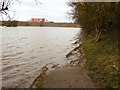
Have a Break
The only way to get to the end of this path Image] by the A1237 is to go back or cut through the trees and bushes right of picture.
Image: © Andy Farrington
Taken: 6 Feb 2011
0.05 miles
5
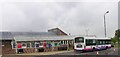
Rawcliffe Park N Ride Terminus
One of many built to cope with the heavy traffic and very poor city parking in York
Image: © Stuart and Fiona Jackson
Taken: 24 May 2005
0.06 miles
7
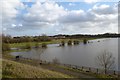
Path along Rawcliffe Ings
The ings are flooded from the Ouse breaking its banks.
Image: © DS Pugh
Taken: 2 Feb 2014
0.08 miles

9
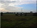
Rawcliffe Ings
Bridge carrying the A1237 over the Ouse.
Image: © DS Pugh
Taken: 14 Jan 2006
0.09 miles
10
Path along Rawcliffe Ings
Cycle route 65 heading north and mostly following the River Ouse for a while.
Image: © DS Pugh
Taken: 26 May 2022
0.09 miles