IMAGES TAKEN NEAR TO
Manor Park Close, YORK, YO30 5UZ
Introduction
This page details the photographs taken nearby to Manor Park Close, YO30 5UZ by members of the Geograph project.
The Geograph project started in 2005 with the aim of publishing, organising and preserving representative images for every square kilometre of Great Britain, Ireland and the Isle of Man.

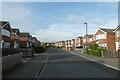
There are currently over 7.5m images from over14,400 individuals and you can help contribute to the project by visiting https://www.geograph.org.uk
Image Map
Images are licensed for reuse under creativecommons.org/licenses/by-sa/2.0
Notes
- Clicking on the map will re-center to the selected point.
- The higher the marker number, the further away the image location is from the centre of the postcode.
Image Listing (16 Images Found)
Images are licensed for reuse under creativecommons.org/licenses/by-sa/2.0
Image
Details
Distance
1
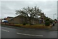
St. Mark's Church
Looking towards the Church on St. Mark's Grove.
Image: © DS Pugh
Taken: 19 Feb 2021
0.04 miles
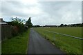
2
Path beside Rawcliffe Recreation Ground
Looking along a path heading towards the pavilion.
Image: © DS Pugh
Taken: 8 Jul 2022
0.12 miles
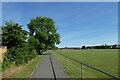
3
Path along playing fields
A foot/cycle path alongside sports fields in Rawcliffe.
Image: © DS Pugh
Taken: 20 Apr 2016
0.13 miles
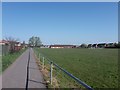
4
Rawcliffe Recreation Ground
Looking along a path beside the recreation ground.
Image: © DS Pugh
Taken: 26 Jun 2023
0.13 miles
5
St. Mark's Grove
Looking along a street in the Rawcliffe area of York.
Image: © DS Pugh
Taken: 22 Sep 2022
0.13 miles
6
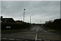
Buttermere Drive
Looking along Buttermere Drive from Westholme Drive.
Image: © DS Pugh
Taken: 19 Feb 2021
0.15 miles
7

Rawcliffe Lake
Man made lake in a housing estate
Image: © Alison Stamp
Taken: 11 May 2005
0.15 miles
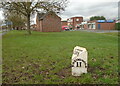
8
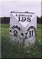
Old Milestone, on the A19, S of A1237 York ring road, in Rawcliffe
Located on the East side of road, on verge. Cast iron post, York casting design, 19th century.
Inscription reads: YORK / 2 // EASINGWOLD / 11 // LONDON / 198
Grade II listed by Historic England. see https://historicengland.org.uk/listing/the-list/list-entry/1149144
Milestone Society National ID: YN_YOTK02
Image: © Christine Minto
Taken: 8 Feb 2006
0.21 miles
9
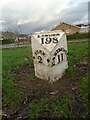
Old milepost
This is the first of the metal posts on the A19 leaving York. It is on the wide verge of Shipton Road. These posts are thought to have been made at the Norby Foundry in Thirsk, run by William & Thomas Chapman. There was a turnpike, York/Thirsk/Northallerton first enacted in 1758 but these posts date from the middle of the 19th century. It is Grade II listed 1149144
Image: © Chris Minto
Taken: 8 Jan 2023
0.21 miles
10
Old milepost
This shows the position of the York 2 milepost on the wide verge of Shipton Road, to the left, and the Post Office van parked on the service road to the right.
Image: © Chris Minto
Taken: 8 Jan 2023
0.21 miles