IMAGES TAKEN NEAR TO
Shipton Road, YORK, YO30 5RR
Introduction
This page details the photographs taken nearby to Shipton Road, YO30 5RR by members of the Geograph project.
The Geograph project started in 2005 with the aim of publishing, organising and preserving representative images for every square kilometre of Great Britain, Ireland and the Isle of Man.

There are currently over 7.5m images from over14,400 individuals and you can help contribute to the project by visiting https://www.geograph.org.uk
Image Map (Loading...)


Getting Data...Please wait
Leaflet Map data © OpenStreetMap
Images are licensed for reuse under creativecommons.org/licenses/by-sa/2.0
Notes
- Clicking on the map will re-center to the selected point.
- The higher the marker number, the further away the image location is from the centre of the postcode.
Image Listing (13 Images Found)
Images are licensed for reuse under creativecommons.org/licenses/by-sa/2.0
Image
Details
Distance
1
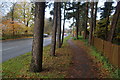
Leafy walk by Shipton Road
The road is the A19 out of York so can be quite busy.
Image: © Bill Boaden
Taken: 17 Nov 2012
0.04 miles
2
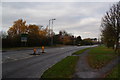
Shipton Road
The A19 passing through Rawcliffe.
Image: © Bill Boaden
Taken: 17 Nov 2012
0.11 miles
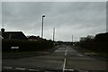
3

Loweswater Road
Looking onto Shipton Road, part of the A19.
Image: © DS Pugh
Taken: 10 Mar 2022
0.13 miles
4
Buttermere Drive
Looking along Buttermere Drive from Westholme Drive.
Image: © DS Pugh
Taken: 19 Feb 2021
0.15 miles
5
Clifton (Without) and Rawcliffe Allotments
Image: © Bill Boaden
Taken: 17 Nov 2012
0.16 miles
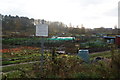
6

Shipton Road allotments
The path leads through to the river path.
Image: © DS Pugh
Taken: 3 Jul 2018
0.16 miles

8
Allotment path
Looking across the allotments between the river and the A19.
Image: © DS Pugh
Taken: 9 May 2020
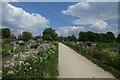
0.19 miles
9
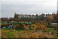
Clifton (Without) and Rawcliffe Allotments
Image: © Bill Boaden
Taken: 17 Nov 2012
0.19 miles
10

Shipton Road Allotments
Looking along a path across the allotments.
Image: © DS Pugh
Taken: 19 Feb 2021
0.19 miles