IMAGES TAKEN NEAR TO
Auster Road, YORK, YO30 4XA
Introduction
This page details the photographs taken nearby to Auster Road, YO30 4XA by members of the Geograph project.
The Geograph project started in 2005 with the aim of publishing, organising and preserving representative images for every square kilometre of Great Britain, Ireland and the Isle of Man.

There are currently over 7.5m images from over14,400 individuals and you can help contribute to the project by visiting https://www.geograph.org.uk
Image Map
Images are licensed for reuse under creativecommons.org/licenses/by-sa/2.0
Notes
- Clicking on the map will re-center to the selected point.
- The higher the marker number, the further away the image location is from the centre of the postcode.
Image Listing (12 Images Found)
Images are licensed for reuse under creativecommons.org/licenses/by-sa/2.0
Image
Details
Distance
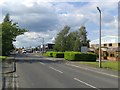
1

Clifton Moor trading estate
Small factory and commercial units on the north side of York. Looking to Auster Road from Audax Road.
Image: © Gordon Hatton
Taken: 22 Oct 2022
0.04 miles
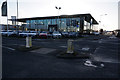
2

Mercedes-Benz of York
Motor dealership on Centurion Way, seen from Clifton Moorgate
Image: © Paul Harrop
Taken: 9 Aug 2016
0.12 miles
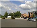
3
Audax Road
Part of Clifton Moor industrial estate.
Image: © DS Pugh
Taken: 3 Jun 2014
0.13 miles
4

Horses in the snow
Horse and foals stand in the snow by the lake in Clifton Moor. A car showroom stands beyond.
Image: © DS Pugh
Taken: 23 Mar 2013
0.14 miles
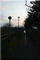
5

Audax Road at dusk
Looking along a road through the trading estate.
Image: © DS Pugh
Taken: 22 May 2021
0.16 miles

8
Canon
Part of Clifton Moor industrial estate.
Image: © DS Pugh
Taken: 3 Jun 2014
0.21 miles
9
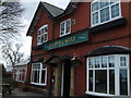
Bumper Castle public house
This pub appears on the OS map from 1853, it was a coaching inn just north of York on Wigginton Road.
Image: © Cathy Brown
Taken: 25 Mar 2008
0.21 miles
10
Unusable cycle path
Significantly submerged cycle path behind the former pub.
Image: © DS Pugh
Taken: 6 Mar 2021
0.25 miles