IMAGES TAKEN NEAR TO
Deer Hill Grove, YORK, YO30 4UE
Introduction
This page details the photographs taken nearby to Deer Hill Grove, YO30 4UE by members of the Geograph project.
The Geograph project started in 2005 with the aim of publishing, organising and preserving representative images for every square kilometre of Great Britain, Ireland and the Isle of Man.

There are currently over 7.5m images from over14,400 individuals and you can help contribute to the project by visiting https://www.geograph.org.uk
Image Map (Loading...)


Getting Data...Please wait
Leaflet Map data © OpenStreetMap
Images are licensed for reuse under creativecommons.org/licenses/by-sa/2.0
Notes
- Clicking on the map will re-center to the selected point.
- The higher the marker number, the further away the image location is from the centre of the postcode.
Image Listing (33 Images Found)
Images are licensed for reuse under creativecommons.org/licenses/by-sa/2.0
Image
Details
Distance
1
Longwood Road
Looking towards Clifton Moor Industrial Estate.
Image: © DS Pugh
Taken: 19 Feb 2021
0.08 miles
2
Clifton Moor
Part of one of the large out of town shopping centres in York. The centre is just within the York ringroad.
Image: © DS Pugh
Taken: 22 Apr 2006
0.08 miles
3
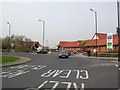
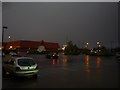
Car park outside Maplin
A downpour of very heavy rain on the Clifton Moor industrial estate, taken from the cover just outside Maplin. The road ahead is Hurricane Way.
Image: © DS Pugh
Taken: 7 Sep 2010
0.09 miles
4
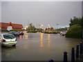
Currys at Clifton Moor
A downpour of very heavy rain on the Clifton Moor industrial estate, taken from the cover just outside Maplin, looking towards Currys. The road ahead is Hurricane Way. The skies really were this dark from the cloud.
Image: © DS Pugh
Taken: 7 Sep 2010
0.10 miles
5
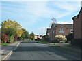
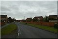
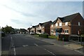
Rivelin Way, Rawcliffe
The area between Shipton Road [A19] and the Clifton Moor retail parks has in recent years been filled in with housing estates of the usual boring suburban type. This is Rivelin Way with Wharnscliffe Drive heading off to the right.
Image: © Gordon Hatton
Taken: 22 Oct 2022
0.10 miles
6
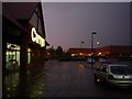
Clifton Moor in the rain
A downpour of very heavy rain on the Clifton Moor industrial estate, taken from the cover just outside Maplin. The road ahead is Hurricane Way. The skies really were this dark from the cloud.
Image: © DS Pugh
Taken: 7 Sep 2010
0.11 miles
7
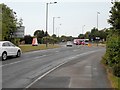
Along Clifton Moor Gate
Heading towards the roundabout at Tescos.
Image: © DS Pugh
Taken: 15 Jan 2014
0.12 miles
9
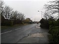
Path crossing Boothwood Road
A cycle path crossing this residential street in Clifton Moor.
Image: © DS Pugh
Taken: 22 Sep 2022
0.13 miles
10
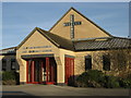
Clifton Moor Church and Community Centre
Church meets 10 am each Sunday, more at http://www.cliftonmoor.org.uk.
Children's activities (play group, Rainbows, after School etc) in term time weekdays.
Social events (quizzes etc).
Image: © Willj
Taken: 4 Feb 2007
0.14 miles