IMAGES TAKEN NEAR TO
Stirling Road, YO30 4AB
Introduction
This page details the photographs taken nearby to Stirling Road, YO30 4AB by members of the Geograph project.
The Geograph project started in 2005 with the aim of publishing, organising and preserving representative images for every square kilometre of Great Britain, Ireland and the Isle of Man.

There are currently over 7.5m images from over14,400 individuals and you can help contribute to the project by visiting https://www.geograph.org.uk
Image Map (Loading...)


Getting Data...Please wait
Leaflet Map data © OpenStreetMap
Images are licensed for reuse under creativecommons.org/licenses/by-sa/2.0
Notes
- Clicking on the map will re-center to the selected point.
- The higher the marker number, the further away the image location is from the centre of the postcode.
Image Listing (9 Images Found)
Images are licensed for reuse under creativecommons.org/licenses/by-sa/2.0
Image
Details
Distance
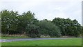
1

Stirling Road
Part of Clifton Moor industrial estate.
Image: © DS Pugh
Taken: 3 Jun 2014
0.02 miles
2

Tenpin
A bowling alley in part of Clifton Moor industrial estate.
Image: © DS Pugh
Taken: 3 Jun 2014
0.07 miles
3

York ring road A1237 passing Clifton Moor Retail Park
York has three retail parks off its ring road Clifton Moor is the largest.
Image: © Martin Dawes
Taken: 5 Feb 2017
0.09 miles
4

York ring road, A1257
Approaching the Clifton Moor roundabout.
Image: © Pauline E
Taken: 24 Jul 2013
0.12 miles

6

Audax Road at dusk
Looking along a road through the trading estate.
Image: © DS Pugh
Taken: 22 May 2021
0.20 miles
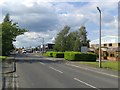
7

Stirling Road from A1237 roundabout
Stirling Road is the eastern entrance into Clifton Moor Retail Park from the York ring road
Image: © Martin Dawes
Taken: 5 Feb 2017
0.20 miles
8
Path and cycle track by roundabout on A1237
Image: © Alpin Stewart
Taken: 9 Sep 2016
0.21 miles
9
Audax Road
Part of Clifton Moor industrial estate.
Image: © DS Pugh
Taken: 3 Jun 2014
0.24 miles