IMAGES TAKEN NEAR TO
Applegarth Cottages, YORK, YO30 2AP
Introduction
This page details the photographs taken nearby to Applegarth Cottages, YO30 2AP by members of the Geograph project.
The Geograph project started in 2005 with the aim of publishing, organising and preserving representative images for every square kilometre of Great Britain, Ireland and the Isle of Man.

There are currently over 7.5m images from over14,400 individuals and you can help contribute to the project by visiting https://www.geograph.org.uk
Image Map
Images are licensed for reuse under creativecommons.org/licenses/by-sa/2.0
Notes
- Clicking on the map will re-center to the selected point.
- The higher the marker number, the further away the image location is from the centre of the postcode.
Image Listing (23 Images Found)
Images are licensed for reuse under creativecommons.org/licenses/by-sa/2.0
Image
Details
Distance
1
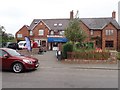
Linton Stores
The only village store for miles around
Image: © Eirian Evans
Taken: 29 May 2018
0.03 miles
4
War Memorial, Linton-on-Ouse
Image: © Eirian Evans
Taken: 29 May 2018
0.03 miles
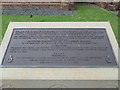
5
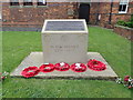
War Memorial, Linton-on-Ouse
The war memorial is placed in front of the village hall, and is dedicated also to Canadian airmen who were stationed at Linton Air Base. See the information panel Image
Image: © Eirian Evans
Taken: 29 May 2018
0.04 miles
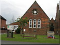
6
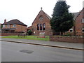
Linton-on-Ouse Village Hall
The village war memorial stands in front of the hall, dedicated also to Canadian airmen who were stationed at Linton Air Base. The old Victorian school, which also served as a Chapel-of-ease, was built in 1871 and closed in 1934. The school premises were given to the Parish of Linton-on-Ouse by Oxford College in 1977 – now used as the Village Hall.
Image: © Eirian Evans
Taken: 29 May 2018
0.04 miles
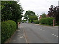
7

School Row, Linton-on-Ouse
A row of terraced houses on the main road
Image: © Eirian Evans
Taken: 29 May 2018
0.06 miles
9
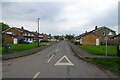
Linton-on-Ouse
The main street running through Linton-on-Ouse, a village that used to be very much dominated by the RAF Airfield. It closed in 2020.
There is much local opposition to plans for an asylum processing centre for 1500 men to be opened in place of the RAF Station. A final decision has yet to be taken.
Image: © Chris Heaton
Taken: 4 Aug 2022
0.12 miles
10
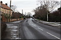
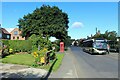
Linton on Ouse Main street looking East
Image: © Michael Jagger
Taken: 31 Dec 2009
0.13 miles