IMAGES TAKEN NEAR TO
Linton On Ouse, YORK, YO30 2AJ
Introduction
This page details the photographs taken nearby to YO30 2AJ by members of the Geograph project.
The Geograph project started in 2005 with the aim of publishing, organising and preserving representative images for every square kilometre of Great Britain, Ireland and the Isle of Man.

There are currently over 7.5m images from over14,400 individuals and you can help contribute to the project by visiting https://www.geograph.org.uk
Image Map (Loading...)


Getting Data...Please wait
Leaflet Map data © OpenStreetMap
Images are licensed for reuse under creativecommons.org/licenses/by-sa/2.0
Notes
- Clicking on the map will re-center to the selected point.
- The higher the marker number, the further away the image location is from the centre of the postcode.
Image Listing (4 Images Found)
Images are licensed for reuse under creativecommons.org/licenses/by-sa/2.0
Image
Details
Distance
1
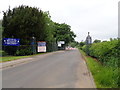
RAF base at Linton-on-Ouse
Opened in 1937 as a bomber airfield, this station now provides Basic Fast Jet Training for those students selected for the Fast Jet stream. https://en.wikipedia.org/wiki/RAF_Linton-on-Ouse
Image: © Eirian Evans
Taken: 29 May 2018
0.12 miles
2
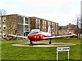
Jet Provost Mk3A
Situated at No1 Flying Training School, RAF Linton-on-Ouse, North Yorkshire.
Used for conversion training to jet propulsion from the 1960's through to 1990's. Image
Image: © Arnold Price
Taken: 29 Mar 2007
0.14 miles
3

Plaque
The plaque beside the Mk3A Jet Provost at RAF Linton-on-Ouse.
Image
Image: © Arnold Price
Taken: 29 Mar 2007
0.14 miles
4
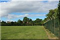
Field beside the Eastern Edge of RAF Linton-on-Ouse - now closed
The RAF Air Base was closed in 2020. Some of the housing at the station has been sold off to the general public.
A final decision on a conversion to an asylum processing centre for 1500 men is awaited. Locally this has amassed much opposition.
Image: © Chris Heaton
Taken: 4 Aug 2022
0.15 miles