IMAGES TAKEN NEAR TO
Moorlands Road, YORK, YO30 1YA
Introduction
This page details the photographs taken nearby to Moorlands Road, YO30 1YA by members of the Geograph project.
The Geograph project started in 2005 with the aim of publishing, organising and preserving representative images for every square kilometre of Great Britain, Ireland and the Isle of Man.

There are currently over 7.5m images from over14,400 individuals and you can help contribute to the project by visiting https://www.geograph.org.uk
Image Map (Loading...)


Getting Data...Please wait
Leaflet Map data © OpenStreetMap
Images are licensed for reuse under creativecommons.org/licenses/by-sa/2.0
Notes
- Clicking on the map will re-center to the selected point.
- The higher the marker number, the further away the image location is from the centre of the postcode.
Image Listing (13 Images Found)
Images are licensed for reuse under creativecommons.org/licenses/by-sa/2.0
Image
Details
Distance
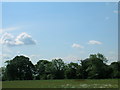
1

St. Catherine's Farm
Situated along Moor Lane near Skelton.
Image: © DS Pugh
Taken: 20 Jul 2008
0.06 miles
2
St. Catherines
St. Catherines holiday cottages.
Image: © DS Pugh
Taken: 14 Jan 2006
0.07 miles
3
Entrance to St Catherines
This is the driveway to some holiday cottages near Skelton.
Image: © DS Pugh
Taken: 20 Jul 2008
0.08 miles
4
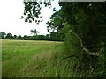
Hedgerow along Moor Lane
Looking along a hedgerow inside a field next to Moor Lane.
Image: © DS Pugh
Taken: 20 Jul 2008
0.10 miles
5

Horses at St Catherines
This is taken from the entrance to some holiday cottages near Skelton.
Image: © DS Pugh
Taken: 20 Jul 2008
0.11 miles
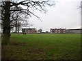
6
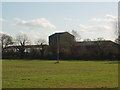
Farm Buildings at Skelton Moor, Skelton, York
Image: © Robert Neilson
Taken: 6 Mar 2007
0.15 miles
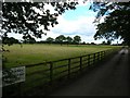
7
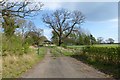
Track off Moor Lane
Leading to farm buildings near Skelton.
Image: © DS Pugh
Taken: 13 Apr 2014
0.16 miles
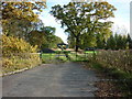
9

Farm track near Skelton
This track runs from a bend in Moor Lane.
Image: © DS Pugh
Taken: 20 Jul 2008
0.18 miles