IMAGES TAKEN NEAR TO
Rawcliffe Landing, YORK, YO30 1XL
Introduction
This page details the photographs taken nearby to Rawcliffe Landing, YO30 1XL by members of the Geograph project.
The Geograph project started in 2005 with the aim of publishing, organising and preserving representative images for every square kilometre of Great Britain, Ireland and the Isle of Man.

There are currently over 7.5m images from over14,400 individuals and you can help contribute to the project by visiting https://www.geograph.org.uk
Image Map
Images are licensed for reuse under creativecommons.org/licenses/by-sa/2.0
Notes
- Clicking on the map will re-center to the selected point.
- The higher the marker number, the further away the image location is from the centre of the postcode.
Image Listing (31 Images Found)
Images are licensed for reuse under creativecommons.org/licenses/by-sa/2.0
Image
Details
Distance
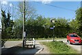
2
Rawcliffe Landing
A road down to the Ouse, used by the National Cycle Network.
Image: © Richard Webb
Taken: 11 Aug 2016
0.01 miles
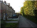
3
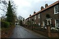
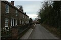
Houses on Rawcliffe Landing
With some decorated for Christmas.
Image: © DS Pugh
Taken: 5 Dec 2021
0.01 miles
4
Sign at Rawcliffe Landing
The sign for York includes many of the well known landmarks.
Image: © DS Pugh
Taken: 24 Apr 2021
0.01 miles
6
Flag near Rawcliffe Landings
Looking along the cycle path as it turns to the left.
Image: © DS Pugh
Taken: 24 Apr 2021
0.02 miles
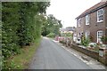
7
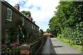
Cottages at Rawcliffe Landing
With various scarecrows in the gardens, including one cottage decorated as a construction site.
Image: © DS Pugh
Taken: 15 Aug 2021
0.02 miles
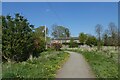
8
Buildings beside the cycle path
Looking across towards farm buildings from National Cycle Network route 65.
Image: © DS Pugh
Taken: 9 Apr 2023
0.05 miles
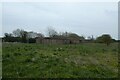
9
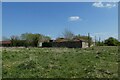
Farm buildings near Rawcliff Landings
15 years on from Image
Image: © DS Pugh
Taken: 24 Apr 2021
0.05 miles
10
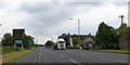
Shipton Road (A19) at Riverside Farm
The farm is now a restaurant; it appears on maps as Rawcliffe Farm, or formerly Clifton Hospital Farm. The sign gives advance notice of the tourist attractions in York, shortly before the by-pass
Image: © David Smith
Taken: 13 Jun 2015
0.08 miles