IMAGES TAKEN NEAR TO
Beningbrough, YORK, YO30 1BZ
Introduction
This page details the photographs taken nearby to YO30 1BZ by members of the Geograph project.
The Geograph project started in 2005 with the aim of publishing, organising and preserving representative images for every square kilometre of Great Britain, Ireland and the Isle of Man.

There are currently over 7.5m images from over14,400 individuals and you can help contribute to the project by visiting https://www.geograph.org.uk
Image Map (Loading...)


Getting Data...Please wait
Leaflet Map data © OpenStreetMap
Images are licensed for reuse under creativecommons.org/licenses/by-sa/2.0
Notes
- Clicking on the map will re-center to the selected point.
- The higher the marker number, the further away the image location is from the centre of the postcode.
Image Listing (33 Images Found)
Images are licensed for reuse under creativecommons.org/licenses/by-sa/2.0
Image
Details
Distance
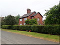
4
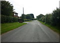
Bellground Lane
Looking along Bellground Lane in Beningbrough.
Image: © DS Pugh
Taken: 16 May 2020
0.07 miles
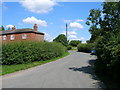
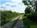
6
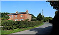
Leaving Beningbrough
Beningbrough Lane leaving the hamlet of the same name
Image: © Chris Heaton
Taken: 18 Sep 2021
0.08 miles
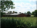
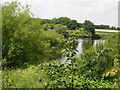
10
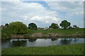
Beningbrough across the Ouse
Looking across the river towards farms in Beningbrough.
Image: © DS Pugh
Taken: 9 May 2020
0.09 miles