IMAGES TAKEN NEAR TO
Main Street, YORK, YO26 9TE
Introduction
This page details the photographs taken nearby to Main Street, YO26 9TE by members of the Geograph project.
The Geograph project started in 2005 with the aim of publishing, organising and preserving representative images for every square kilometre of Great Britain, Ireland and the Isle of Man.

There are currently over 7.5m images from over14,400 individuals and you can help contribute to the project by visiting https://www.geograph.org.uk
Image Map (Loading...)


Getting Data...Please wait
Leaflet Map data © OpenStreetMap
Images are licensed for reuse under creativecommons.org/licenses/by-sa/2.0
Notes
- Clicking on the map will re-center to the selected point.
- The higher the marker number, the further away the image location is from the centre of the postcode.
Image Listing (20 Images Found)
Images are licensed for reuse under creativecommons.org/licenses/by-sa/2.0
Image
Details
Distance
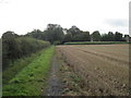
1
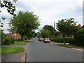
Little Ouseburn
The closest end to the B6265.
Image: © DS Pugh
Taken: 15 Jun 2006
0.04 miles
2
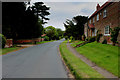
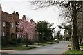
Main Street, Little Ouseburn
Most of the village is arranged on either of side Main Street in a ribbon formation - with many of the substantial dwellings set well back in delightful gardens.
Image: © Chris Heaton
Taken: 14 Jul 2015
0.09 miles
3
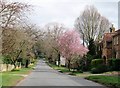
Little Ouseburn village street
Little Ouseburn is very much a linear village comprising a single street with properties to either side. Very much a commuter village midway between Harrogate and York.
Image: © Gordon Hatton
Taken: 17 Mar 2020
0.12 miles
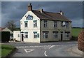
6

The Green Tree
Public house at Little Ouseburn.
Image: © DS Pugh
Taken: 8 Aug 2015
0.15 miles
7
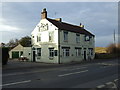
The Green tree pub, Little Ouseburn
On the B6265, old Roman Road.
Image: © JThomas
Taken: 30 Nov 2013
0.15 miles
8
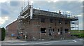
Housing development on Green Tree Inn site, Little Ouseburn
According to the OS benchmark database there is a benchmark cut into the south-east face of the Inn at the east angle. The pub has been demolished and new housing is being built on the site.
Image: © Mel Towler
Taken: 23 Apr 2023
0.15 miles
9
The Green Tree, Little Ouseburn
Small public house situated at the extreme western end of the village of Little Ouseburn on the B6265 (Dere Street)
The establishment was closed on my visit, so was unable to sample the delights within.
Image: © Chris Heaton
Taken: 14 Jul 2015
0.17 miles
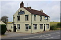
10
The Green Tree, Little Ouseburn
Pub situated at the west end of the village at the side of the York to Boroughbridge road. The road is the B6265 which takes a scenic route from Green S Hammerton to Skipton via Boroughbridge, Ripon, Pateley Bridge and Grassington. In decades past it was the A167 and when roads were first given numbers in the 1920's it was the A66.
Image: © Gordon Hatton
Taken: 17 Mar 2020
0.17 miles