IMAGES TAKEN NEAR TO
Church Field Lane, YORK, YO26 9SG
Introduction
This page details the photographs taken nearby to Church Field Lane, YO26 9SG by members of the Geograph project.
The Geograph project started in 2005 with the aim of publishing, organising and preserving representative images for every square kilometre of Great Britain, Ireland and the Isle of Man.

There are currently over 7.5m images from over14,400 individuals and you can help contribute to the project by visiting https://www.geograph.org.uk
Image Map
Images are licensed for reuse under creativecommons.org/licenses/by-sa/2.0
Notes
- Clicking on the map will re-center to the selected point.
- The higher the marker number, the further away the image location is from the centre of the postcode.
Image Listing (111 Images Found)
Images are licensed for reuse under creativecommons.org/licenses/by-sa/2.0
Image
Details
Distance
1
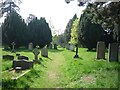
Great Ouseburn graveyard
Looking into the graveyard from Church Field Lane.
Image: © DS Pugh
Taken: 21 Apr 2011
0.04 miles
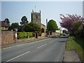
2
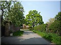
Along Church Field Lane
Looking from the graveyard entrance along the road.
Image: © DS Pugh
Taken: 21 Apr 2011
0.04 miles
3
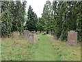
Pathway through the graveyard of St Mary's Church, Great Ouseburn
Looking north-eastward.
Image: © Peter Wood
Taken: 5 Sep 2018
0.05 miles
4

St Mary the Virgin, Great Ouseburn - Font
Image: © John Salmon
Taken: 28 Dec 2017
0.05 miles
5
Church of St Mary The Virgin, Great Ouseburn.
Image: © Bill Henderson
Taken: 6 Sep 2007
0.05 miles
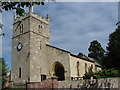
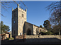
6
Great Ouseburn Church
The church of St. Mary.
Image: © DS Pugh
Taken: 21 Apr 2011
0.05 miles
8

St Mary the Virgin, Great Ouseburn - Chancel
Image: © John Salmon
Taken: 28 Dec 2017
0.05 miles
9
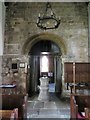
St Mary's church interior
The 12th century archway leading into the tower.
Image: © Gordon Hatton
Taken: 17 Mar 2020
0.05 miles
10
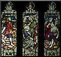
St Mary the Virgin, Great Ouseburn - Stained glass window
Image: © John Salmon
Taken: 28 Dec 2017
0.05 miles