IMAGES TAKEN NEAR TO
Springfield Rise, YORK, YO26 9SE
Introduction
This page details the photographs taken nearby to Springfield Rise, YO26 9SE by members of the Geograph project.
The Geograph project started in 2005 with the aim of publishing, organising and preserving representative images for every square kilometre of Great Britain, Ireland and the Isle of Man.

There are currently over 7.5m images from over14,400 individuals and you can help contribute to the project by visiting https://www.geograph.org.uk
Image Map (Loading...)


Getting Data...Please wait
Leaflet Map data © OpenStreetMap
Images are licensed for reuse under creativecommons.org/licenses/by-sa/2.0
Notes
- Clicking on the map will re-center to the selected point.
- The higher the marker number, the further away the image location is from the centre of the postcode.
Image Listing (107 Images Found)
Images are licensed for reuse under creativecommons.org/licenses/by-sa/2.0
Image
Details
Distance
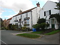

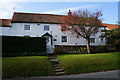
3
Great Ouseburn
Looking along Great Ouseburn. On the right is the Crown Inn public house.
Image: © DS Pugh
Taken: 5 Aug 2007
0.05 miles

6
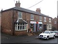
Great Ouseburn Post Office and General Store
A rare sight in any village nowadays.
Image: © Oliver Dixon
Taken: 16 Nov 2018
0.06 miles
8
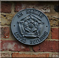
English Listed Building Plaque
On Well Farm, Main Street, Great Ouseburn.
Image: © Ian S
Taken: 30 Sep 2014
0.06 miles
9
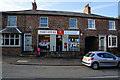
Post Office and General Store, Great Ouseburn
Image: © Ian S
Taken: 30 Sep 2014
0.06 miles
