IMAGES TAKEN NEAR TO
Lower Dunsforth, YORK, YO26 9SB
Introduction
This page details the photographs taken nearby to YO26 9SB by members of the Geograph project.
The Geograph project started in 2005 with the aim of publishing, organising and preserving representative images for every square kilometre of Great Britain, Ireland and the Isle of Man.

There are currently over 7.5m images from over14,400 individuals and you can help contribute to the project by visiting https://www.geograph.org.uk
Image Map (Loading...)


Getting Data...Please wait
Leaflet Map data © OpenStreetMap
Images are licensed for reuse under creativecommons.org/licenses/by-sa/2.0
Notes
- Clicking on the map will re-center to the selected point.
- The higher the marker number, the further away the image location is from the centre of the postcode.
Image Listing (6 Images Found)
Images are licensed for reuse under creativecommons.org/licenses/by-sa/2.0
Image
Details
Distance
1
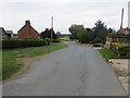
Hunday Field Road at Whitwell Field
Looking north-eastward.
Image: © Peter Wood
Taken: 5 Sep 2018
0.01 miles
2

Houses at Whitwell Field
On Mary Lane, Lower Dunsforth. Followed by National Cycle Network route 688 from Linton-on-Ouse to Winterburn, near Gargrave, which forms the central part of the Way of the Roses Cycle Route.
Image: © Oliver Dixon
Taken: 16 Nov 2018
0.02 miles
3
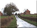
Hunday Field lane
Minor road that links the village of Lower Dunsforth with the B6265.
Image: © Gordon Hatton
Taken: 13 Feb 2014
0.03 miles
4
On Mary Lane approaching Mount Pleasant Farm
Image: © Phil Catterall
Taken: 5 Mar 2007
0.04 miles
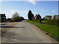
5

Mount Pleasant Farm
View from Hunday Field Road.
Image: © David Rogers
Taken: 17 Aug 2010
0.04 miles
6
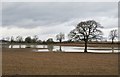
Wet field near Grafton Lodge
Following a very wet February, the ground here has still not dried halfway through March. This is simply standing water and not caused by watercourses overflowing.
Image: © Gordon Hatton
Taken: 17 Mar 2020
0.23 miles