IMAGES TAKEN NEAR TO
Branton Green, YORK, YO26 9RT
Introduction
This page details the photographs taken nearby to Branton Green, YO26 9RT by members of the Geograph project.
The Geograph project started in 2005 with the aim of publishing, organising and preserving representative images for every square kilometre of Great Britain, Ireland and the Isle of Man.

There are currently over 7.5m images from over14,400 individuals and you can help contribute to the project by visiting https://www.geograph.org.uk
Image Map (Loading...)


Getting Data...Please wait
Leaflet Map data © OpenStreetMap
Images are licensed for reuse under creativecommons.org/licenses/by-sa/2.0
Notes
- Clicking on the map will re-center to the selected point.
- The higher the marker number, the further away the image location is from the centre of the postcode.
Image Listing (4 Images Found)
Images are licensed for reuse under creativecommons.org/licenses/by-sa/2.0
Image
Details
Distance
2
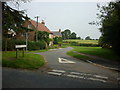
Road into Great Ouseburn
Great Ouseburn has its own small 'suburb' on this side where the houses line the road through Branton Green, current building developments slowly filling the gaps between the two communities.
Image: © Gordon Hatton
Taken: 17 Mar 2020
0.15 miles
3
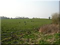
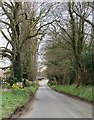
Sheep - Great Ouseburn
On the road to Upper Dunsforth.
Image: © DS Pugh
Taken: 28 Mar 2007
0.24 miles
4
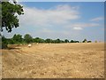
Bales between Upper Dunsforth and Great Ouseburn
Along the road to Upper Dunsforth are several fields of stubble, having had the crops cut for straw bales.
Image: © DS Pugh
Taken: 5 Aug 2007
0.25 miles