IMAGES TAKEN NEAR TO
Moor Monkton, YORK, YO26 8JG
Introduction
This page details the photographs taken nearby to YO26 8JG by members of the Geograph project.
The Geograph project started in 2005 with the aim of publishing, organising and preserving representative images for every square kilometre of Great Britain, Ireland and the Isle of Man.

There are currently over 7.5m images from over14,400 individuals and you can help contribute to the project by visiting https://www.geograph.org.uk
Image Map
Images are licensed for reuse under creativecommons.org/licenses/by-sa/2.0
Notes
- Clicking on the map will re-center to the selected point.
- The higher the marker number, the further away the image location is from the centre of the postcode.
Image Listing (32 Images Found)
Images are licensed for reuse under creativecommons.org/licenses/by-sa/2.0
Image
Details
Distance
1
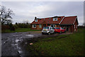
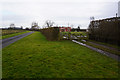
Thickpenny Farm
Seen from the northern end of Scagglethorpe Lane.
Image: © Ken Crosby
Taken: 11 May 2006
0.02 miles
3
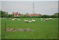
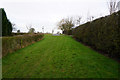
Bridleway to Poppleton
Looking along the track near Thickpenny Farm to Poppleton.
Image: © DS Pugh
Taken: 7 May 2023
0.03 miles
8
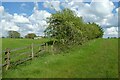
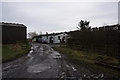
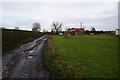
Fence and hedgerow near Thickpenny Farm
A bridleway runs along the edge of the field to Poppleton.
Image: © DS Pugh
Taken: 7 May 2023
0.07 miles
9
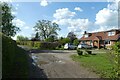
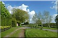
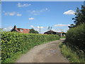
House near Thickpenny Farm
The track leads through to Moor Monkton.
Image: © DS Pugh
Taken: 7 May 2023
0.08 miles