IMAGES TAKEN NEAR TO
York Road, YORK, YO26 8HZ
Introduction
This page details the photographs taken nearby to York Road, YO26 8HZ by members of the Geograph project.
The Geograph project started in 2005 with the aim of publishing, organising and preserving representative images for every square kilometre of Great Britain, Ireland and the Isle of Man.

There are currently over 7.5m images from over14,400 individuals and you can help contribute to the project by visiting https://www.geograph.org.uk
Image Map
Images are licensed for reuse under creativecommons.org/licenses/by-sa/2.0
Notes
- Clicking on the map will re-center to the selected point.
- The higher the marker number, the further away the image location is from the centre of the postcode.
Image Listing (7 Images Found)
Images are licensed for reuse under creativecommons.org/licenses/by-sa/2.0
Image
Details
Distance
5
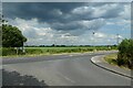
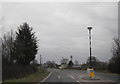
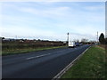
Junction with the A59
New Road from Hessay meets the A59 York to Harrogate road.
Image: © DS Pugh
Taken: 25 Jun 2023
0.22 miles
7
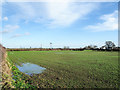
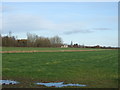
Field with emerging crop... and standing water
The ground lies just south of the A59 - it's just beyond the hedge at the field's end. Following a very wet autumn locally (and generally), in early winter the water table is almost at the land's surface resulting in areas of standing water.
Image: © Trevor Littlewood
Taken: 11 Dec 2019
0.24 miles