IMAGES TAKEN NEAR TO
Nun Monkton, YORK, YO26 8EU
Introduction
This page details the photographs taken nearby to YO26 8EU by members of the Geograph project.
The Geograph project started in 2005 with the aim of publishing, organising and preserving representative images for every square kilometre of Great Britain, Ireland and the Isle of Man.

There are currently over 7.5m images from over14,400 individuals and you can help contribute to the project by visiting https://www.geograph.org.uk
Image Map
Images are licensed for reuse under creativecommons.org/licenses/by-sa/2.0
Notes
- Clicking on the map will re-center to the selected point.
- The higher the marker number, the further away the image location is from the centre of the postcode.
Image Listing (5 Images Found)
Images are licensed for reuse under creativecommons.org/licenses/by-sa/2.0
Image
Details
Distance
1
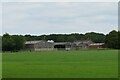
Grange Farm
Agricultural buildings at Grange Farm, Nun Monkton.
Image: © Gordon Hatton
Taken: 10 Jun 2021
0.06 miles
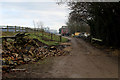
3
Towards Grange Farm, near Nun Monkton
Image: © Nigel Thompson
Taken: 14 May 2013
0.21 miles
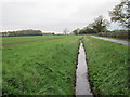
4
A copse named 'America'
Unusual name for woodland near Grange Farm, Nun Monkton.
Image: © Jonathan Billinger
Taken: 6 Dec 2006
0.24 miles
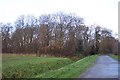
5
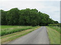
America is well wooded
An odd name for a small block of woodland near Nun Monkton.
Image: © Gordon Hatton
Taken: 10 Jun 2021
0.25 miles