IMAGES TAKEN NEAR TO
Long Marston, YORK, YO26 7LN
Introduction
This page details the photographs taken nearby to YO26 7LN by members of the Geograph project.
The Geograph project started in 2005 with the aim of publishing, organising and preserving representative images for every square kilometre of Great Britain, Ireland and the Isle of Man.

There are currently over 7.5m images from over14,400 individuals and you can help contribute to the project by visiting https://www.geograph.org.uk
Image Map
Images are licensed for reuse under creativecommons.org/licenses/by-sa/2.0
Notes
- Clicking on the map will re-center to the selected point.
- The higher the marker number, the further away the image location is from the centre of the postcode.
Image Listing (25 Images Found)
Images are licensed for reuse under creativecommons.org/licenses/by-sa/2.0
Image
Details
Distance
2
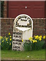
Long Marston Milepost
Beside the B1224, 7 miles from York.
Image: © David Rogers
Taken: 6 Apr 2010
0.02 miles
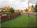
4
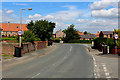
Angram Road, Long Marston
Approaching the B1224 in the village of Long Marston
Image: © Chris Heaton
Taken: 4 Jul 2016
0.03 miles
5
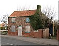
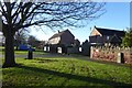
In need of a little TLC
A rather ramshackle cottage near the crossroads in Long Marston.
Image: © Gordon Hatton
Taken: 25 Feb 2008
0.03 miles
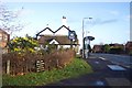
6
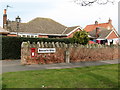
Long Marston Post Office
The post office in this village occupies a room in a residential bungalow.
Image: © Gordon Hatton
Taken: 25 Feb 2008
0.03 miles
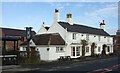
7
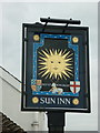
The Sun Inn, Long Marston
A Sam Smith's public house
Image: © Ian S
Taken: 12 Mar 2011
0.04 miles
8
Letterbox in Long Marston
Looking towards Butt Hedge from Angram Road.
Image: © DS Pugh
Taken: 26 Nov 2017
0.04 miles
9
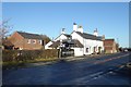
The Sun Inn
Looking across Wetherby Road towards the Sun Inn in Long Marston.
Image: © DS Pugh
Taken: 26 Nov 2017
0.04 miles