IMAGES TAKEN NEAR TO
Rudgate, YORK, YO26 7DW
Introduction
This page details the photographs taken nearby to Rudgate, YO26 7DW by members of the Geograph project.
The Geograph project started in 2005 with the aim of publishing, organising and preserving representative images for every square kilometre of Great Britain, Ireland and the Isle of Man.

There are currently over 7.5m images from over14,400 individuals and you can help contribute to the project by visiting https://www.geograph.org.uk
Image Map
Images are licensed for reuse under creativecommons.org/licenses/by-sa/2.0
Notes
- Clicking on the map will re-center to the selected point.
- The higher the marker number, the further away the image location is from the centre of the postcode.
Image Listing (6 Images Found)
Images are licensed for reuse under creativecommons.org/licenses/by-sa/2.0
Image
Details
Distance
1
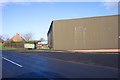
J Revis & Sons
Transport and warehousing company.
Image: © Jonathan Billinger
Taken: 6 Dec 2006
0.03 miles
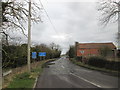
3
Near Southfield Lodge
Looking along Southfield Lane to the south of the former airfield.
Image: © DS Pugh
Taken: 31 May 2020
0.14 miles
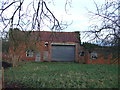
5
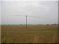
Tockwith airfield
Electric wires covered in birds at the edge of the former airfield at Tockwith.
Image: © DS Pugh
Taken: 25 Sep 2006
0.23 miles
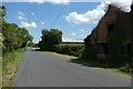
6
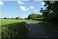
Along Southfield Lane
Looking along Southfield Lane beside the former airfield.
Image: © DS Pugh
Taken: 31 May 2020
0.24 miles