IMAGES TAKEN NEAR TO
Marston Moor Business Park, YO26 7AF
Introduction
This page details the photographs taken nearby to Marston Moor Business Park, YO26 7AF by members of the Geograph project.
The Geograph project started in 2005 with the aim of publishing, organising and preserving representative images for every square kilometre of Great Britain, Ireland and the Isle of Man.

There are currently over 7.5m images from over14,400 individuals and you can help contribute to the project by visiting https://www.geograph.org.uk
Image Map (Loading...)


Getting Data...Please wait
Leaflet Map data © OpenStreetMap
Images are licensed for reuse under creativecommons.org/licenses/by-sa/2.0
Notes
- Clicking on the map will re-center to the selected point.
- The higher the marker number, the further away the image location is from the centre of the postcode.
Image Listing (11 Images Found)
Images are licensed for reuse under creativecommons.org/licenses/by-sa/2.0
Image
Details
Distance
1
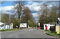
Entrance to Marston Business Park
The business park is on part of the old Tockwith airfield and utilises some of the former RAF buildings.
Image: © Gordon Hatton
Taken: 5 Apr 2021
0.10 miles
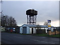
3

Marston Business Park
Situated on the former airfield at Tockwith. Like many airfields in this area it is now a business park and industrial estate.
Image: © DS Pugh
Taken: 25 Sep 2006
0.13 miles
4
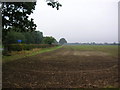
Farmland at Tockwith crossroads
To the left is the crossroads of the Tockwith to Cowthorpe and Cattal roads.
Image: © DS Pugh
Taken: 25 Sep 2006
0.15 miles
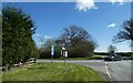
6

Crossroads on Tockwith Road
Turn left for Cattal
Image: © Martin Dawes
Taken: 9 Jul 2016
0.21 miles
7
Crossroads west of Tockwith
Tockwith Lane meets Cattal Moor Road, Fleet Lane and Rudgate.
Image: © DS Pugh
Taken: 5 Apr 2021
0.21 miles
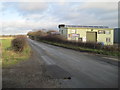
8
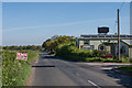
Rudgate
Former Roman Road running from Tadcaster to Whixley. On the right, utilising the buildings of the former RAF Marston Moor (aka Tockwith Airfield) is Rudgate Business Park.
Image: © Ian Capper
Taken: 3 May 2014
0.23 miles
9
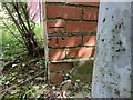
Cattal, BT building
The benchmark is cut into the left of the south face of the brick BT building.
Image: © Mel Towler
Taken: 10 Jun 2022
0.24 miles
10
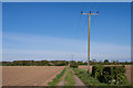
Moor Side
Track leading from Rudgate to Moor Side,
Image: © Ian Capper
Taken: 3 May 2014
0.24 miles