IMAGES TAKEN NEAR TO
Nursery Court, YORK, YO26 6LR
Introduction
This page details the photographs taken nearby to Nursery Court, YO26 6LR by members of the Geograph project.
The Geograph project started in 2005 with the aim of publishing, organising and preserving representative images for every square kilometre of Great Britain, Ireland and the Isle of Man.

There are currently over 7.5m images from over14,400 individuals and you can help contribute to the project by visiting https://www.geograph.org.uk
Image Map
Images are licensed for reuse under creativecommons.org/licenses/by-sa/2.0
Notes
- Clicking on the map will re-center to the selected point.
- The higher the marker number, the further away the image location is from the centre of the postcode.
Image Listing (18 Images Found)
Images are licensed for reuse under creativecommons.org/licenses/by-sa/2.0
Image
Details
Distance
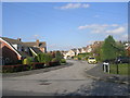
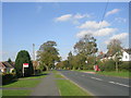
1
Millfield Lane looking north, Nether Poppleton
Image: © Nigel Thompson
Taken: 13 May 2013
0.09 miles
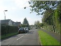
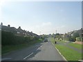
3
Millfield Lane - viewed from Long Ridge Lane
Image: © Betty Longbottom
Taken: 22 Oct 2011
0.12 miles
4

Odd Tree to be found in Nether Poppleton
Located near the junction of Long Ridge Lane and Millfield Lane, Poppleton near York.
Image: © Chris Heaton
Taken: 12 Mar 2022
0.12 miles
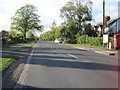
6

Millfield Lane - viewed from Long Ridge Lane
Image: © Betty Longbottom
Taken: 22 Oct 2011
0.12 miles
7

Poppleton Tigers Juniors Football Club
Image: © Chris Heaton
Taken: 12 Mar 2022
0.13 miles
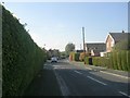
8

Millfield Gardens - Millfield Lane
Image: © Betty Longbottom
Taken: 22 Oct 2011
0.14 miles