IMAGES TAKEN NEAR TO
Hodgson Lane, YORK, YO26 6EA
Introduction
This page details the photographs taken nearby to Hodgson Lane, YO26 6EA by members of the Geograph project.
The Geograph project started in 2005 with the aim of publishing, organising and preserving representative images for every square kilometre of Great Britain, Ireland and the Isle of Man.

There are currently over 7.5m images from over14,400 individuals and you can help contribute to the project by visiting https://www.geograph.org.uk
Image Map
Images are licensed for reuse under creativecommons.org/licenses/by-sa/2.0
Notes
- Clicking on the map will re-center to the selected point.
- The higher the marker number, the further away the image location is from the centre of the postcode.
Image Listing (77 Images Found)
Images are licensed for reuse under creativecommons.org/licenses/by-sa/2.0
Image
Details
Distance
1
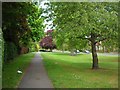
Upper Poppleton
A wide verge in Upper Poppleton.
Image: © DS Pugh
Taken: 12 May 2007
0.01 miles
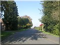
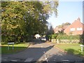
2
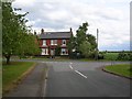
Houses in Upper Poppleton
Left to the village, right to the A59.
Image: © DS Pugh
Taken: 12 May 2007
0.01 miles
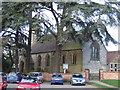
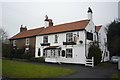
3
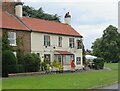
The Lord Collingwood pub
Situated on a corner at the south western end of the village.
Image: © Gordon Hatton
Taken: 12 Jul 2023
0.03 miles
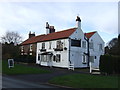
4
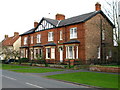
Upper Poppleton Village
Impressive double fronted semi on Hodgson Lane.
Image: © David Rogers
Taken: 16 Mar 2009
0.03 miles
6
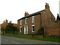
Fern House
In the village of Upper Poppleton.
Image: © David Rogers
Taken: 16 Mar 2009
0.04 miles
8
Lord Collingwood
The Lord Collingwood public house in Upper Poppleton. This road leads to the A59.
Image: © DS Pugh
Taken: 7 Feb 2010
0.08 miles