IMAGES TAKEN NEAR TO
Boroughbridge Road, YORK, YO26 5SH
Introduction
This page details the photographs taken nearby to Boroughbridge Road, YO26 5SH by members of the Geograph project.
The Geograph project started in 2005 with the aim of publishing, organising and preserving representative images for every square kilometre of Great Britain, Ireland and the Isle of Man.

There are currently over 7.5m images from over14,400 individuals and you can help contribute to the project by visiting https://www.geograph.org.uk
Image Map
Images are licensed for reuse under creativecommons.org/licenses/by-sa/2.0
Notes
- Clicking on the map will re-center to the selected point.
- The higher the marker number, the further away the image location is from the centre of the postcode.
Image Listing (23 Images Found)
Images are licensed for reuse under creativecommons.org/licenses/by-sa/2.0
Image
Details
Distance
1
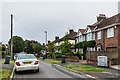
Malvern Avenue
1930s housing off Boroughbridge Road.
Image: © Ian Capper
Taken: 19 Jul 2017
0.07 miles
2
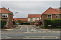
Sandacre Court
Cul-de-sac off Boroughbridge Road containing sheltered housing provided by the Joseph Rowntree Housing trust.
Image: © Ian Capper
Taken: 19 Jul 2017
0.09 miles
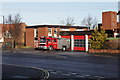
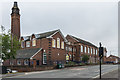
4
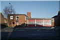
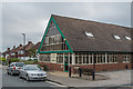
Acomb fire station
Acomb fire station, Boroughbridge Road, Acomb, York, North Yorkshire
Image: © Kevin Hale
Taken: 6 Dec 2009
0.12 miles
5
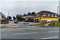
Manor Drive North
Road off Boroughbridge Road developed in the 1930s. On the corner is a Premier convenience store.
Image: © Ian Capper
Taken: 19 Jul 2017
0.12 miles
6
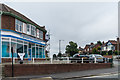
The Washing Well
Commercial laundry and laundrette on the corner of Lavender Grove and Boroughbridge Road.
Image: © Ian Capper
Taken: 19 Jul 2017
0.14 miles
7
Lavender Grove Surgery
Doctors' surgery in Lavender Grove operated by the Priory Medical Group. Lavender Grove itself was first partly developed in the 19th Century, but most of the housing was built in the 1930s, such as the houses seen in the background here.
Image: © Ian Capper
Taken: 19 Jul 2017
0.14 miles
8
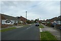
Along Almsford Road
Looking towards Carr Lane.
Image: © DS Pugh
Taken: 1 Jul 2021
0.18 miles
9
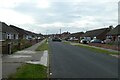
Almsford Road
Looking along a street in Acomb.
Image: © DS Pugh
Taken: 1 Jul 2021
0.20 miles
10
Poppleton Road Primary School
Primary school at the junction of Water End with Poppleton Road. It was designed by York Architect Walter Brierley and built 1903-4. Grade II listed - see www.historicengland.org.uk/listing/the-list/list-entry/1256903.
Image: © Ian Capper
Taken: 19 Jul 2017
0.22 miles