IMAGES TAKEN NEAR TO
Ouseburn Avenue, YORK, YO26 5NL
Introduction
This page details the photographs taken nearby to Ouseburn Avenue, YO26 5NL by members of the Geograph project.
The Geograph project started in 2005 with the aim of publishing, organising and preserving representative images for every square kilometre of Great Britain, Ireland and the Isle of Man.

There are currently over 7.5m images from over14,400 individuals and you can help contribute to the project by visiting https://www.geograph.org.uk
Image Map
Images are licensed for reuse under creativecommons.org/licenses/by-sa/2.0
Notes
- Clicking on the map will re-center to the selected point.
- The higher the marker number, the further away the image location is from the centre of the postcode.
Image Listing (19 Images Found)
Images are licensed for reuse under creativecommons.org/licenses/by-sa/2.0
Image
Details
Distance
1
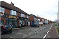
Shops on Boroughbridge Road
The Lucky Dragon Chinese and a hair salon.
Image: © DS Pugh
Taken: 2 Feb 2014
0.09 miles
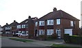
4
Wheatlands Grove
Semi detached suburbia on the west side of York, mostly developed in the 1930's.
Image: © Gordon Hatton
Taken: 25 Nov 2009
0.11 miles
6
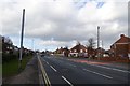
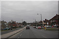
Boroughbridge Road
Looking along Boroughbridge Road with shops ahead on the right.
Image: © DS Pugh
Taken: 2 Feb 2014
0.12 miles
7
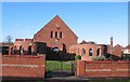
Lidgett Grove Methodist Church
Built in 1933 as this suburb of York was developing.
Image: © Gordon Hatton
Taken: 25 Nov 2009
0.13 miles
9
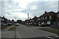
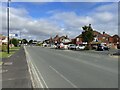
Along Almsford Road
Looking along Almsford Road towards Beckfield Lane.
Image: © DS Pugh
Taken: 1 Jul 2021
0.15 miles
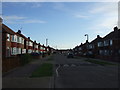
10
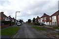
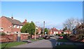
Lidgett Grove
Looking towards Beckfield Lane.
Image: © DS Pugh
Taken: 2 Feb 2014
0.18 miles