IMAGES TAKEN NEAR TO
Jubilee Terrace, YORK, YO26 4YZ
Introduction
This page details the photographs taken nearby to Jubilee Terrace, YO26 4YZ by members of the Geograph project.
The Geograph project started in 2005 with the aim of publishing, organising and preserving representative images for every square kilometre of Great Britain, Ireland and the Isle of Man.

There are currently over 7.5m images from over14,400 individuals and you can help contribute to the project by visiting https://www.geograph.org.uk
Image Map (Loading...)


Getting Data...Please wait
Leaflet Map data © OpenStreetMap
Images are licensed for reuse under creativecommons.org/licenses/by-sa/2.0
Notes
- Clicking on the map will re-center to the selected point.
- The higher the marker number, the further away the image location is from the centre of the postcode.
Image Listing (134 Images Found)
Images are licensed for reuse under creativecommons.org/licenses/by-sa/2.0
Image
Details
Distance
1
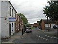
Jubilee Terrace - off Salisbury Terrace
Image: © Betty Longbottom
Taken: 25 Sep 2010
0.01 miles

3

St Barnabas Close - Jubilee Terrace
Image: © Betty Longbottom
Taken: 25 Sep 2010
0.04 miles
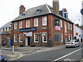
5
St Barnabas Church - Jubilee Terrace
Image: © Betty Longbottom
Taken: 25 Sep 2010
0.05 miles
6
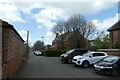
Jubilee Terrace
Looking along Jubilee Terrace which connects Leeman Park to Salisbury Terrace. St. Barnabas Church is ahead.
Image: © DS Pugh
Taken: 24 Apr 2022
0.05 miles
7
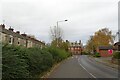
Kingsland Terrace
Looking towards Salisbury Terrace.
Image: © DS Pugh
Taken: 12 Nov 2023
0.05 miles
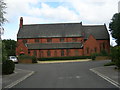
8
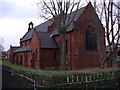
Ghastly & Gothic
St.Barnabas Parish Church, at the end of Jubilee Terrace was built 1902-4 by Hornsey & Monkman.
Image: © Matthew Hatton
Taken: 3 Feb 2007
0.05 miles

10

Balfour Street - Salisbury Terrace
Image: © Betty Longbottom
Taken: 25 Sep 2010
0.06 miles