IMAGES TAKEN NEAR TO
Forth Street, YORK, YO26 4YS
Introduction
This page details the photographs taken nearby to Forth Street, YO26 4YS by members of the Geograph project.
The Geograph project started in 2005 with the aim of publishing, organising and preserving representative images for every square kilometre of Great Britain, Ireland and the Isle of Man.

There are currently over 7.5m images from over14,400 individuals and you can help contribute to the project by visiting https://www.geograph.org.uk
Image Map
Images are licensed for reuse under creativecommons.org/licenses/by-sa/2.0
Notes
- Clicking on the map will re-center to the selected point.
- The higher the marker number, the further away the image location is from the centre of the postcode.
Image Listing (157 Images Found)
Images are licensed for reuse under creativecommons.org/licenses/by-sa/2.0
Image
Details
Distance

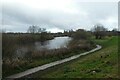
5
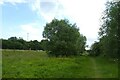
Path near Water End
Looking along a path on the river bank beside the Ouse.
Image: © DS Pugh
Taken: 14 Jun 2022
0.07 miles
6
Riverside path near Water End
Looking along a path on the banks of the River Ouse.
Image: © DS Pugh
Taken: 14 Jun 2022
0.08 miles
8
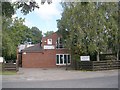
The Minster Veterinary Practice - Salisbury Road
Image: © Betty Longbottom
Taken: 25 Sep 2010
0.09 miles

10
Clifton Short Reach
Looking downstream along the River Ouse from Water End.
Image: © DS Pugh
Taken: 5 Dec 2021
0.09 miles