IMAGES TAKEN NEAR TO
Walgate Park, YO25 5LL
Introduction
This page details the photographs taken nearby to Walgate Park, YO25 5LL by members of the Geograph project.
The Geograph project started in 2005 with the aim of publishing, organising and preserving representative images for every square kilometre of Great Britain, Ireland and the Isle of Man.

There are currently over 7.5m images from over14,400 individuals and you can help contribute to the project by visiting https://www.geograph.org.uk
Image Map
Images are licensed for reuse under creativecommons.org/licenses/by-sa/2.0
Notes
- Clicking on the map will re-center to the selected point.
- The higher the marker number, the further away the image location is from the centre of the postcode.
Image Listing (24 Images Found)
Images are licensed for reuse under creativecommons.org/licenses/by-sa/2.0
Image
Details
Distance
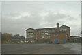
1
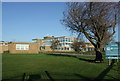
Driffield School - "Upper School" Building
Image: © Trevor Fowler
Taken: 31 Dec 2006
0.09 miles
2

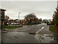
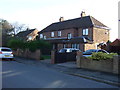
Manorfield Road, Driffield
Entrance to Driffield School.
Image: © JThomas
Taken: 20 Dec 2014
0.11 miles

7
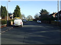
Manorfield Road, Driffield
Heading north east towards Driffield School.
Image: © JThomas
Taken: 20 Dec 2014
0.16 miles
8
Driffield School - "Lower School" Building
Image: © Trevor Fowler
Taken: 31 Dec 2006
0.16 miles