IMAGES TAKEN NEAR TO
Foxholes, DRIFFIELD, YO25 3QE
Introduction
This page details the photographs taken nearby to YO25 3QE by members of the Geograph project.
The Geograph project started in 2005 with the aim of publishing, organising and preserving representative images for every square kilometre of Great Britain, Ireland and the Isle of Man.

There are currently over 7.5m images from over14,400 individuals and you can help contribute to the project by visiting https://www.geograph.org.uk
Image Map (Loading...)


Getting Data...Please wait
Leaflet Map data © OpenStreetMap
Images are licensed for reuse under creativecommons.org/licenses/by-sa/2.0
Notes
- Clicking on the map will re-center to the selected point.
- The higher the marker number, the further away the image location is from the centre of the postcode.
Image Listing (16 Images Found)
Images are licensed for reuse under creativecommons.org/licenses/by-sa/2.0
Image
Details
Distance
2

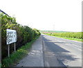
Entering Foxholes on B1249
A crossroads just past the house on the right, left to Weaverthorpe right to Low Newton.
Image: © Martin Dawes
Taken: 25 Jul 2016
0.05 miles
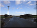
6
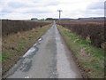
Lane to Octon
Looking south down the narrow towards Octon.
Image: © Stephen Horncastle
Taken: 18 Mar 2006
0.11 miles
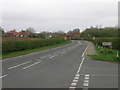
7

Approaching Foxholes from the south on B1249
Two industrial units to the right the first Foxholes Garage
Image: © Martin Dawes
Taken: 25 Jul 2016
0.12 miles
9
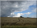
Wheat waiting to be harvested near Foxholes
Rain yesterday and rain forecast for today will mean this crop will have to wait a little longer.
Image: © Jonathan Thacker
Taken: 1 Sep 2017
0.19 miles
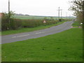
10
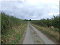
Heading south east from Foxholes
Minor road towards Octon.
Image: © JThomas
Taken: 8 Oct 2016
0.19 miles