IMAGES TAKEN NEAR TO
Langtoft, DRIFFIELD, YO25 3BW
Introduction
This page details the photographs taken nearby to YO25 3BW by members of the Geograph project.
The Geograph project started in 2005 with the aim of publishing, organising and preserving representative images for every square kilometre of Great Britain, Ireland and the Isle of Man.

There are currently over 7.5m images from over14,400 individuals and you can help contribute to the project by visiting https://www.geograph.org.uk
Image Map
Images are licensed for reuse under creativecommons.org/licenses/by-sa/2.0
Notes
- Clicking on the map will re-center to the selected point.
- The higher the marker number, the further away the image location is from the centre of the postcode.
Image Listing (16 Images Found)
Images are licensed for reuse under creativecommons.org/licenses/by-sa/2.0
Image
Details
Distance
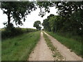
2
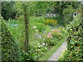
A Real Cottage Garden
Pasture Cottage the front garden is the artists dream of a true English cottage garden straight off a card or a chocolate box.
Image: © Martin Dawes
Taken: 16 Jul 2008
0.01 miles
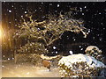
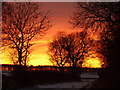
3
Green lane sunset
Green Lane looking towards Croome Wood
Image: © Pat
Taken: 4 Jan 2010
0.02 miles
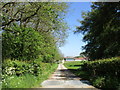
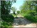
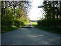
4
Green Lane (track) approaching lane junction
To the left are Pasture Cottages, to the right end of field before wooded disused pit
Image: © Martin Dawes
Taken: 23 Feb 2022
0.02 miles
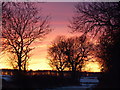
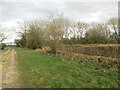
9
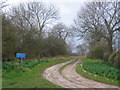
Byway
The byway heads SW into the adjacent square where it turns north.
Image: © Stephen Horncastle
Taken: 8 Apr 2006
0.10 miles