IMAGES TAKEN NEAR TO
Green Lane, YORK, YO24 3DL
Introduction
This page details the photographs taken nearby to Green Lane, YO24 3DL by members of the Geograph project.
The Geograph project started in 2005 with the aim of publishing, organising and preserving representative images for every square kilometre of Great Britain, Ireland and the Isle of Man.

There are currently over 7.5m images from over14,400 individuals and you can help contribute to the project by visiting https://www.geograph.org.uk
Image Map
Images are licensed for reuse under creativecommons.org/licenses/by-sa/2.0
Notes
- Clicking on the map will re-center to the selected point.
- The higher the marker number, the further away the image location is from the centre of the postcode.
Image Listing (90 Images Found)
Images are licensed for reuse under creativecommons.org/licenses/by-sa/2.0
Image
Details
Distance

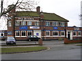
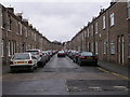
3
Across Green Lane roundabout
Part of the York suburb of Acomb, which saw rapid development from the mid 1930's. This area has wide streets lined with a mix of private and local authority housing. On the far side of the roundabout is the Acomb public house.
Image: © Gordon Hatton
Taken: 26 Feb 2009
0.09 miles

5
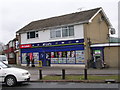
McColl's Off Licence - Green Lane Circle
Image: © Betty Longbottom
Taken: 6 Mar 2010
0.10 miles
6

Belly Buster Takeaway - Green Lane Circle
Image: © Betty Longbottom
Taken: 6 Mar 2010
0.10 miles
8
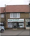
Circle Cleaners - Green Lane Circle
Image: © Betty Longbottom
Taken: 6 Mar 2010
0.11 miles
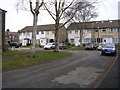
9
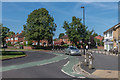
Roundabout, Low Field
Roundabout in Low Field, where Green Lane is met by Hamilton Drive West, Kingsthorpe, Tudor Road and Kingsway West. Prior to the 1930s Green Lane was a lane connecting Acomb with Hob Moor; housing development on this and on the surrounding roads started in the 1930s and continued in the 1950s.
Image: © Ian Capper
Taken: 18 Jul 2017
0.11 miles