IMAGES TAKEN NEAR TO
Bolton Percy, YORK, YO23 7AU
Introduction
This page details the photographs taken nearby to YO23 7AU by members of the Geograph project.
The Geograph project started in 2005 with the aim of publishing, organising and preserving representative images for every square kilometre of Great Britain, Ireland and the Isle of Man.

There are currently over 7.5m images from over14,400 individuals and you can help contribute to the project by visiting https://www.geograph.org.uk
Image Map
Images are licensed for reuse under creativecommons.org/licenses/by-sa/2.0
Notes
- Clicking on the map will re-center to the selected point.
- The higher the marker number, the further away the image location is from the centre of the postcode.
Image Listing (5 Images Found)
Images are licensed for reuse under creativecommons.org/licenses/by-sa/2.0
Image
Details
Distance
3
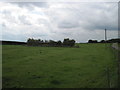
Pond at Pallathorpe Farm
The bushes mark the pond
Image: © Martin Dawes
Taken: 31 Aug 2011
0.09 miles
4
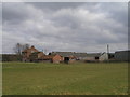
Pallathorpe Farm
Some of the fields of Pallathorpe Farm taken from partway up the drive on a cold, wet January afternoon.
Image: © DS Pugh
Taken: 29 Jan 2006
0.11 miles
5
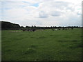
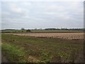
Cattle and Sheep in the same field. Pallathorpe Farm
Keeping an eye on us as we used the footpath across their field.The bull is the brown one in the distance behind the black calf. Beef bulls are allowed in fields with footpaths through them.
Image: © Martin Dawes
Taken: 31 Aug 2011
0.14 miles