IMAGES TAKEN NEAR TO
Wilstrop Farm Road, YORK, YO23 3RY
Introduction
This page details the photographs taken nearby to Wilstrop Farm Road, YO23 3RY by members of the Geograph project.
The Geograph project started in 2005 with the aim of publishing, organising and preserving representative images for every square kilometre of Great Britain, Ireland and the Isle of Man.

There are currently over 7.5m images from over14,400 individuals and you can help contribute to the project by visiting https://www.geograph.org.uk
Image Map
Images are licensed for reuse under creativecommons.org/licenses/by-sa/2.0
Notes
- Clicking on the map will re-center to the selected point.
- The higher the marker number, the further away the image location is from the centre of the postcode.
Image Listing (89 Images Found)
Images are licensed for reuse under creativecommons.org/licenses/by-sa/2.0
Image
Details
Distance
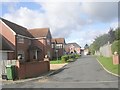
1
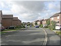
Wilstrop Farm Road - off Main Street
Image: © Betty Longbottom
Taken: 17 Sep 2011
0.01 miles
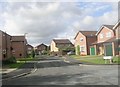
2
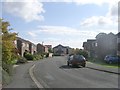
Wilstrop Farm Road - looking towards Main Street
Image: © Betty Longbottom
Taken: 17 Sep 2011
0.03 miles
3
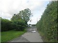
Low Westfield Road - off Back Lane
Image: © Betty Longbottom
Taken: 17 Sep 2011
0.03 miles
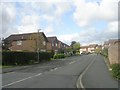
4
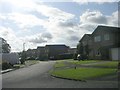
Barnfield Way - Wilstrop Farm Road
Image: © Betty Longbottom
Taken: 17 Sep 2011
0.04 miles
6
Homefield Close - Wilstrop Farm Road
Image: © Betty Longbottom
Taken: 17 Sep 2011
0.06 miles
8

Main Street - viewed from Wilstrop Farm Road
Image: © Betty Longbottom
Taken: 17 Sep 2011
0.08 miles
9
Main Street - viewed from Wilstrop Farm Road
Image: © Betty Longbottom
Taken: 17 Sep 2011
0.08 miles
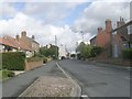
10

Along Main Street
Looking along Main Street in Copmanthorpe.
Image: © DS Pugh
Taken: 21 Aug 2021
0.09 miles