IMAGES TAKEN NEAR TO
Sim Balk Lane, YORK, YO23 2BB
Introduction
This page details the photographs taken nearby to Sim Balk Lane, YO23 2BB by members of the Geograph project.
The Geograph project started in 2005 with the aim of publishing, organising and preserving representative images for every square kilometre of Great Britain, Ireland and the Isle of Man.

There are currently over 7.5m images from over14,400 individuals and you can help contribute to the project by visiting https://www.geograph.org.uk
Image Map
Images are licensed for reuse under creativecommons.org/licenses/by-sa/2.0
Notes
- Clicking on the map will re-center to the selected point.
- The higher the marker number, the further away the image location is from the centre of the postcode.
Image Listing (52 Images Found)
Images are licensed for reuse under creativecommons.org/licenses/by-sa/2.0
Image
Details
Distance
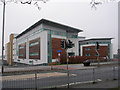
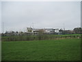
1
York College
As seen from the Trans Pennine Trail.
Image: © Peter Church
Taken: 24 Mar 2009
0.03 miles
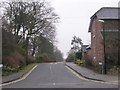
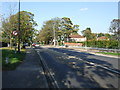
3
Tadcaster Road, Dringhouses
Looking towards York city centre a little way north of Askham Bar.
Image: © Richard Vince
Taken: 10 Apr 2015
0.06 miles
5
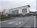
York College
Largely intended for students aged 16 - 19. It dominates the south western fringe of the city.
Image: © Jonathan Thacker
Taken: 2 Jan 2013
0.07 miles
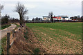
7
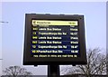
End of the walk
Time for the bus back to Tadcaster, west bank
Image: © Chris Morgan
Taken: 18 Jan 2016
0.07 miles
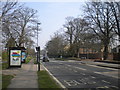
8
Chessingham Gardens - Tadcaster Road
Image: © Betty Longbottom
Taken: 27 Feb 2010
0.08 miles
9
The Grove - looking towards Tadcaster Road
Image: © Betty Longbottom
Taken: 31 May 2017
0.08 miles