IMAGES TAKEN NEAR TO
Pheasant Way, YORK, YO23 2AB
Introduction
This page details the photographs taken nearby to Pheasant Way, YO23 2AB by members of the Geograph project.
The Geograph project started in 2005 with the aim of publishing, organising and preserving representative images for every square kilometre of Great Britain, Ireland and the Isle of Man.

There are currently over 7.5m images from over14,400 individuals and you can help contribute to the project by visiting https://www.geograph.org.uk
Image Map
Images are licensed for reuse under creativecommons.org/licenses/by-sa/2.0
Notes
- Clicking on the map will re-center to the selected point.
- The higher the marker number, the further away the image location is from the centre of the postcode.
Image Listing (6 Images Found)
Images are licensed for reuse under creativecommons.org/licenses/by-sa/2.0
Image
Details
Distance
1
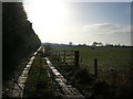
South from Intake Lane
There were sheep next to the fence, but my arrival startled them.
Image: © DS Pugh
Taken: 23 Nov 2008
0.03 miles
2
From Intake Lane
Looking north from Intake Lane.
Image: © DS Pugh
Taken: 23 Nov 2008
0.16 miles
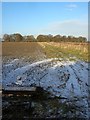
3

Footpath heading towards Stub Wood
Following a deep ditch, after leaving Intake Lane
Image: © Chris Heaton
Taken: 29 Jul 2019
0.21 miles
4
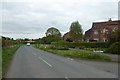
Lakeside
Looking along Intake Lane at the entrance to Lakeside.
Image: © DS Pugh
Taken: 29 Apr 2017
0.21 miles

6
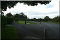
Intake Lane
Looking along Intake Lane in Acaster Malbis.
Image: © DS Pugh
Taken: 15 Oct 2022
0.22 miles