IMAGES TAKEN NEAR TO
Count De Burgh Terrace, YORK, YO23 1HP
Introduction
This page details the photographs taken nearby to Count De Burgh Terrace, YO23 1HP by members of the Geograph project.
The Geograph project started in 2005 with the aim of publishing, organising and preserving representative images for every square kilometre of Great Britain, Ireland and the Isle of Man.

There are currently over 7.5m images from over14,400 individuals and you can help contribute to the project by visiting https://www.geograph.org.uk
Image Map
Images are licensed for reuse under creativecommons.org/licenses/by-sa/2.0
Notes
- Clicking on the map will re-center to the selected point.
- The higher the marker number, the further away the image location is from the centre of the postcode.
Image Listing (139 Images Found)
Images are licensed for reuse under creativecommons.org/licenses/by-sa/2.0
Image
Details
Distance
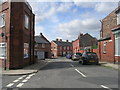
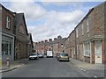
1

Eastern End of Brunswick Street, York
Within the Micklegate electoral ward in York
Image: © Chris Heaton
Taken: 9 Jul 2022
0.01 miles
2
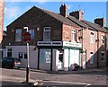
Southbank Stores
Corner shop on Queen Victoria Street in the South Bank area of the city.
Image: © Gordon Hatton
Taken: 25 Nov 2009
0.02 miles
3
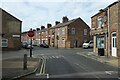
Junction with Count De Burgh Terrace
Looking across the junction onto Queen Victoria Street from Balmoral Terrace in Southbank.
Image: © DS Pugh
Taken: 9 Oct 2022
0.03 miles
4
Brunswick Street - Trafalgar Street
Image: © Betty Longbottom
Taken: 20 Aug 2011
0.03 miles
5
Trafalgar Street - South Bank Avenue
Image: © Betty Longbottom
Taken: 20 Aug 2011
0.03 miles
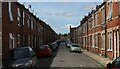
6
Balmoral Terrace - Trafalgar Street
Image: © Betty Longbottom
Taken: 20 Aug 2011
0.04 miles
7
Brunswick Street, York
Within the Micklegate Ward, to the south of York City Centre.
Image: © Chris Heaton
Taken: 9 Jul 2022
0.04 miles
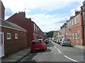
8
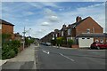
Southbank Avenue
Looking along Southbank Avenue near the junction with Trafalgar Street.
Image: © DS Pugh
Taken: 16 Jul 2023
0.05 miles
9
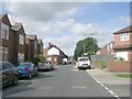
South Bank Avenue - viewed from Nunthorpe Grove
Image: © Betty Longbottom
Taken: 20 Aug 2011
0.05 miles
10
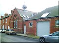
Former chapel, South Bank Avenue
This building appears on the OS 6" map of 1907 as a 'Mission Chapel' [or possibly Mission Church], but is not shown on any maps of a later [or earlier] date. One assumes that its use as a religious site was rather short, and I have no idea as to its current use.
Image: © Gordon Hatton
Taken: 20 Feb 2015
0.06 miles