IMAGES TAKEN NEAR TO
Gascoigne Walk, YORK, YO23 1BY
Introduction
This page details the photographs taken nearby to Gascoigne Walk, YO23 1BY by members of the Geograph project.
The Geograph project started in 2005 with the aim of publishing, organising and preserving representative images for every square kilometre of Great Britain, Ireland and the Isle of Man.

There are currently over 7.5m images from over14,400 individuals and you can help contribute to the project by visiting https://www.geograph.org.uk
Image Map
Images are licensed for reuse under creativecommons.org/licenses/by-sa/2.0
Notes
- Clicking on the map will re-center to the selected point.
- The higher the marker number, the further away the image location is from the centre of the postcode.
Image Listing (463 Images Found)
Images are licensed for reuse under creativecommons.org/licenses/by-sa/2.0
Image
Details
Distance
1

City Walls
Next to Clementhorpe, the City walls in full spring bloom.
Image: © DS Pugh
Taken: 4 Apr 2006
0.05 miles
2
Corner of Newton and Baille Hill terraces
As seen from York city wall near Bitchdaughter Tower.
Image: © Stanley Howe
Taken: 19 Apr 2007
0.05 miles
3
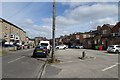
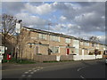
St. Benedict Road
With the backs of the shops along Bishopthorpe Road on the right.
Image: © DS Pugh
Taken: 21 Apr 2024
0.05 miles
4
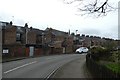
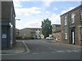
St. Benedict Road
Looking along St. Benedict Road at the back of houses on Nunthorpe Road.
Image: © DS Pugh
Taken: 22 Feb 2020
0.05 miles
5
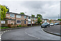
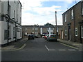
St Benedict Road
1960s redevelopment of an area of Victorian terraced housing.
Image: © Ian Capper
Taken: 21 May 2021
0.05 miles