IMAGES TAKEN NEAR TO
Kingston Garth, WHITBY, YO22 4UN
Introduction
This page details the photographs taken nearby to Kingston Garth, YO22 4UN by members of the Geograph project.
The Geograph project started in 2005 with the aim of publishing, organising and preserving representative images for every square kilometre of Great Britain, Ireland and the Isle of Man.

There are currently over 7.5m images from over14,400 individuals and you can help contribute to the project by visiting https://www.geograph.org.uk
Image Map (Loading...)


Getting Data...Please wait
Leaflet Map data © OpenStreetMap
Images are licensed for reuse under creativecommons.org/licenses/by-sa/2.0
Notes
- Clicking on the map will re-center to the selected point.
- The higher the marker number, the further away the image location is from the centre of the postcode.
Image Listing (69 Images Found)
Images are licensed for reuse under creativecommons.org/licenses/by-sa/2.0
Image
Details
Distance
1
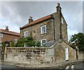
Fylingthorpe, Rose Cottage
There is a benchmark cut into the east facing boundary wall of Rose Cottage. The mark is cut into a stone in the 3rd course.
Image: © Mel Towler
Taken: 26 Sep 2022
0.04 miles
2
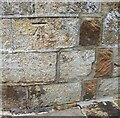
Fylingthorpe, Rose Cottage
The benchmark is cut into the east facing boundary wall of Rose Cottage.
Image: © Mel Towler
Taken: 26 Sep 2022
0.04 miles
3
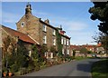
Thorpe Green, Fylingthorpe
This is a fine group of late 18th century buildings. The group in the foreground are Listed Buildings as is the stone house in the background. The closest single storey building is the former smithy.
Image: © Christopher Hall
Taken: 1 Oct 2014
0.04 miles
4
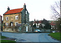
House on the corner of Thorpe Green Bank and Church Lane, Fylingthorpe
There is a sundial above the door. The house was built in the late 18C according to the listing details.
Image: © Humphrey Bolton
Taken: 4 Feb 2014
0.05 miles
5
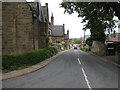
View down Thorpe Green Bank
This photograph shows a view down Thorpe Green Bank towards Middlewood Lane from Thorpe Bank. Kingston Garth is just visible emerging from the right-hand side of the road (near the second car). The picture was taken looking in an east-south-easterly direction towards Boggle Hole.
Image: © Philip Barker
Taken: 30 May 2010
0.05 miles

8

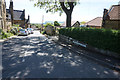
Thorpe Green Bank, Fylingthorpe
Residential street to the south of the centre of the village.
Image: © Barbara Carr
Taken: 20 Jun 2013
0.07 miles
10
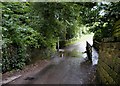
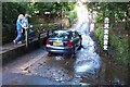
Ford across Thorpe Beck
The road drops down flanked by walls made of the local sandstone (Saltwick formation). The path over the bridge carries on beyond as a raised causeway
Image: © Christopher Hall
Taken: 8 Jun 2014
0.09 miles