IMAGES TAKEN NEAR TO
Fylingdales, WHITBY, YO22 4QN
Introduction
This page details the photographs taken nearby to YO22 4QN by members of the Geograph project.
The Geograph project started in 2005 with the aim of publishing, organising and preserving representative images for every square kilometre of Great Britain, Ireland and the Isle of Man.

There are currently over 7.5m images from over14,400 individuals and you can help contribute to the project by visiting https://www.geograph.org.uk
Image Map
Images are licensed for reuse under creativecommons.org/licenses/by-sa/2.0
Notes
- Clicking on the map will re-center to the selected point.
- The higher the marker number, the further away the image location is from the centre of the postcode.
Image Listing (12 Images Found)
Images are licensed for reuse under creativecommons.org/licenses/by-sa/2.0
Image
Details
Distance
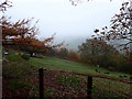
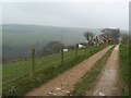
1
Meadow to Partridge Hill Farm
From the moorland a green valley running down to the coast
Image: © Martin Dawes
Taken: 17 Jun 2012
0.09 miles
2
Into Ramsdale
From the footpath over the moor to Kirk Moor Gate
Image: © Martin Dawes
Taken: 17 Jun 2012
0.11 miles
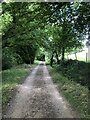
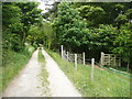
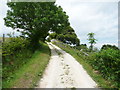
3
Lane to Oakwood
Bridleway to the smallholding of Oakwood
Image: © Stephen McCulloch
Taken: 30 Mar 2007
0.18 miles
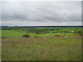
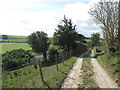
4
Bridleway from Fylingthorpe to Ramsdale
Image: © Humphrey Bolton
Taken: 28 Jun 2015
0.20 miles
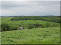
5
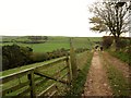
Bridleway to Ramsdale
From Fyling Hall to Ramsdale Mill and beyond. Ramsdale Beck runs through the wood on the left
Image: © Martin Dawes
Taken: 2 Nov 2016
0.21 miles
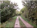
7
Bridleway from Fylingthorpe to Ramsdale
Image: © Humphrey Bolton
Taken: 28 Jun 2015
0.22 miles
8
Track and bridleway through Oak Wood Ramsdale
Toward Ramsdale Mill
Image: © Martin Dawes
Taken: 2 Nov 2016
0.23 miles