IMAGES TAKEN NEAR TO
Stainsacre, WHITBY, YO22 4PA
Introduction
This page details the photographs taken nearby to YO22 4PA by members of the Geograph project.
The Geograph project started in 2005 with the aim of publishing, organising and preserving representative images for every square kilometre of Great Britain, Ireland and the Isle of Man.

There are currently over 7.5m images from over14,400 individuals and you can help contribute to the project by visiting https://www.geograph.org.uk
Image Map (Loading...)


Getting Data...Please wait
Leaflet Map data © OpenStreetMap
Images are licensed for reuse under creativecommons.org/licenses/by-sa/2.0
Notes
- Clicking on the map will re-center to the selected point.
- The higher the marker number, the further away the image location is from the centre of the postcode.
Image Listing (33 Images Found)
Images are licensed for reuse under creativecommons.org/licenses/by-sa/2.0
Image
Details
Distance
4
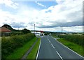
Filling station, Summerfield Lane and A171 junction, Stainsacre
Image: © N Chadwick
Taken: 4 Jun 2010
0.04 miles
5
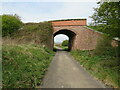
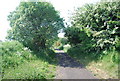
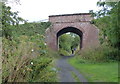
Cinder Track near Stainsacre
A view along the Cinder Track, a walking and cycling trail which follows the route of a dismantled railway from Whitby to Scarborough. The Cinder Track forms part of the route of National Cycle Network route 1. Here the path passes under a minor road.
Image: © Malc McDonald
Taken: 28 Apr 2021
0.05 miles

7
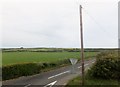
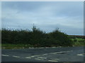
Summerfield Lane
To the east of the A171, near Stainsacre.
Image: © Barbara Carr
Taken: 20 Jun 2013
0.05 miles
8
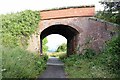
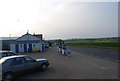
Bridge over the Cinder Track at Stainsacre
Bridge carrying Summerfield Lane over the Cinder Track at Stainsacre.
The Cinder Track, also known as the "Scarborough to Whitby Rail Trail" and "Scarborough to Whitby Cinder Track", is a 21 mile multi-use path following the track of the old Scarborough and Whitby Railway. The railway operated from 1885 to 1965 when it was closed as part of the Beeching Axe.
Wikipedia https://en.wikipedia.org/wiki/Scarborough_and_Whitby_Railway
Image: © Jeff Buck
Taken: 30 Jun 2022
0.05 miles
9
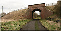
Road Bridge near Stainsacre
The bridge crosses the disused Whitby to Scarborough railway line.
Image: © Peter Church
Taken: 29 Mar 2008
0.06 miles
10
Summerfield Lane crossing the Cinder Track at Stainsacre
Image: © Mat Fascione
Taken: 10 Aug 2018
0.06 miles