IMAGES TAKEN NEAR TO
Spital Bridge, WHITBY, YO22 4EG
Introduction
This page details the photographs taken nearby to Spital Bridge, YO22 4EG by members of the Geograph project.
The Geograph project started in 2005 with the aim of publishing, organising and preserving representative images for every square kilometre of Great Britain, Ireland and the Isle of Man.

There are currently over 7.5m images from over14,400 individuals and you can help contribute to the project by visiting https://www.geograph.org.uk
Image Map (Loading...)


Getting Data...Please wait
Leaflet Map data © OpenStreetMap
Images are licensed for reuse under creativecommons.org/licenses/by-sa/2.0
Notes
- Clicking on the map will re-center to the selected point.
- The higher the marker number, the further away the image location is from the centre of the postcode.
Image Listing (323 Images Found)
Images are licensed for reuse under creativecommons.org/licenses/by-sa/2.0
Image
Details
Distance
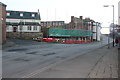
1

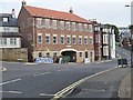
Hoggarth's Lemonade Factory, Spital Bridge
Formerly a well known local business, this building faces demolition; along with more buildings to the rear, to be replaced with 7 town houses.
Despite the council calling it an eyesore, it is a great shame that the original frontage could not be kept, as the stone ground floor is believed to be part of an 18thC warehouse.
Too much of our history has already been lost due to town councillors not having enough vision.
Image: © Matthew Hatton
Taken: 20 Dec 2015
0.01 miles
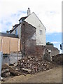
2
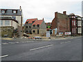
Half way down
The old Hoggarths lemonade factory half way demolished. Presumably the rest will be down soon.
Image: © Michael Williamson
Taken: 22 Jan 2017
0.01 miles
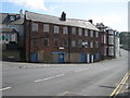
3
Construction site at Spital Bridge
Work taking place on the site of the former Hoggarth's lemonade factory.
See also Image] (2015) and Image] (Jan 2017)
Image: © E Gammie
Taken: 14 Sep 2017
0.01 miles
4
Hoggarth's drinks factory
Whitby was an important fishing town, reaching the height of its prosperity in the 18th century. Maritime industries were attracted to the town, including sail making. A former sailcloth factory, dating from the late 18th century, is seen here. Latterly a drinks factory, the building is currently disused.
Image: © Mike Kirby
Taken: 8 Jul 2009
0.01 miles
5
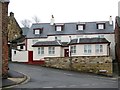
Another one bites the dust
The Bottom House, a former public house, see Image, is now an apartment block.
Image: © Mike Kirby
Taken: 16 Feb 2012
0.02 miles
6
Nearly there
Redevelopment of the former lemonade factory is nearly complete and will shortly be available for occupation. See Image for an earlier photo.
Image: © Michael Williamson
Taken: 24 Jul 2019
0.02 miles
8

Cut Bench Mark on Hoggarth's Lemonade Factory
Presumably this will be lost when the site is redeveloped.
It is recorded on the Benchmarks Database. See link: http://www.bench-marks.org.uk/bm72320
Image: © Matthew Hatton
Taken: 20 Dec 2015
0.02 miles
9
Spital Bridge
Leading to Church Street.
Image: © David Rogers
Taken: 22 Feb 2010
0.02 miles
10
Development site by Spital Bridge (road), Whitby
Formerly occupied by an industrial building, the site was being developed for housing. An Ordnance Survey benchmark was still in place at the left of the site when this photograph was taken, but it seems to have been lost as the development progressed Image
Image: © John S Turner
Taken: 17 Jun 2018
0.02 miles