IMAGES TAKEN NEAR TO
Dunsley, WHITBY, YO21 3TL
Introduction
This page details the photographs taken nearby to YO21 3TL by members of the Geograph project.
The Geograph project started in 2005 with the aim of publishing, organising and preserving representative images for every square kilometre of Great Britain, Ireland and the Isle of Man.

There are currently over 7.5m images from over14,400 individuals and you can help contribute to the project by visiting https://www.geograph.org.uk
Image Map
Images are licensed for reuse under creativecommons.org/licenses/by-sa/2.0
Notes
- Clicking on the map will re-center to the selected point.
- The higher the marker number, the further away the image location is from the centre of the postcode.
Image Listing (17 Images Found)
Images are licensed for reuse under creativecommons.org/licenses/by-sa/2.0
Image
Details
Distance
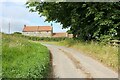
1
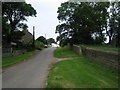
Country lane approaching Dunsley Manor
Image: © Phil Catterall
Taken: 15 Jun 2006
0.02 miles
3
Rear of Dunsley Hall Hotel
This is the same building as in first geograph Dunsley Manor - not sure if it's correctly called a Manor or Hall.
Image: © Colin Grice
Taken: 19 Jun 2006
0.12 miles
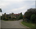
4
Dunsley Hall, Dunsley
The rear of Dunsley Hall, a country house hotel, seen from Dunley Lane.
Image: © Jeff Buck
Taken: 27 Jun 2022
0.12 miles
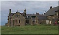
6
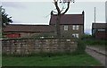
Home Farm - Dunsley
Farm set by the small village green at Dunsley.
Image: © Colin Grice
Taken: 19 Jun 2006
0.13 miles
7
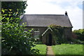
Disused church at Dunsley
Shown as a church or chapel on the map, this looks to have been unused for some time
Image: © Stephen McCulloch
Taken: 7 Jun 2007
0.13 miles
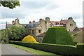
8
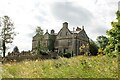
Dunsley Hall
Dunsley Hall, a country house hotel in Dunsley.
Image: © Jeff Buck
Taken: 27 Jun 2022
0.13 miles
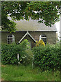
9

Low Farm, Dunsley
Low Farm on the west of Dunsley.
Image: © Jeff Buck
Taken: 27 Jun 2022
0.14 miles
10
A lane in Dunsley
Looking towards Low Farm in the middle of Dunsley.
Image: © Jeff Buck
Taken: 27 Jun 2022
0.15 miles